Accurate estimates of cropped area, crop type distributions and irrigation practices play an important role in guiding policy decisions related to food and water security. Due to the wide variety of landscape dynamics, crop types, growing seasons and agricultural management practices, the accurate and detailed mapping of these aspects at the global scale still remains a very challenging task. The first global crop maps either lacked spatial detail or failed to provide regular updates. For this reason, the European Space Agency, in collaboration with stakeholders in global agriculture like GEOGLAM and FAO, has initiated the WorldCereal project to provide an open-source processing system able of generating season-specific agricultural monitoring information at field level (10 m resolution) and global scale, entirely based on open and free data.
During the first phase of the project (2020 - 2023), the WorldCereal consortium successfully demonstrated the scientific and technical feasibility of growing season-specific crop mapping at high resolution and global scale: WorldCereal, access 10 m seasonally-updated crop type maps at global scale.
As a result, in 2023, WorldCereal released the first set of global, seasonally updated temporary crop extent, crop type and irrigation maps at 10m resolution for the year 2021. In short, one global temporary crop extent map was produced for the entire year, after which growing season specific crop type, irrigation and active cropland masks have been produced for up to 3 growing seasons globally (one primary cereals season, one main maize season and an optional second maize season). Crop type products include maize, winter cereals and spring cereals, where “cereals” are defined as a combination of wheat, barley and rye. More information on exact product definitions and ways to access these products can be found on this page.
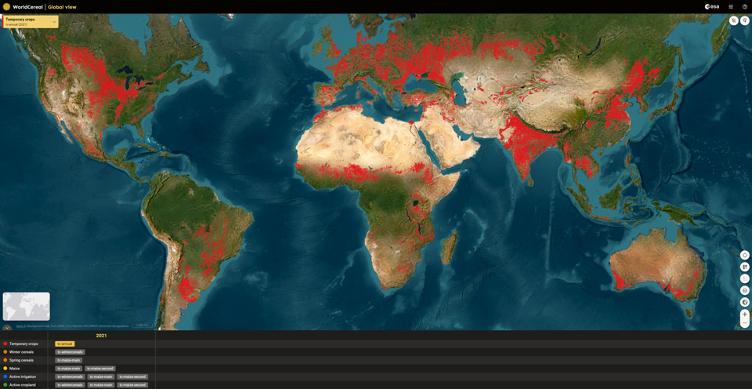
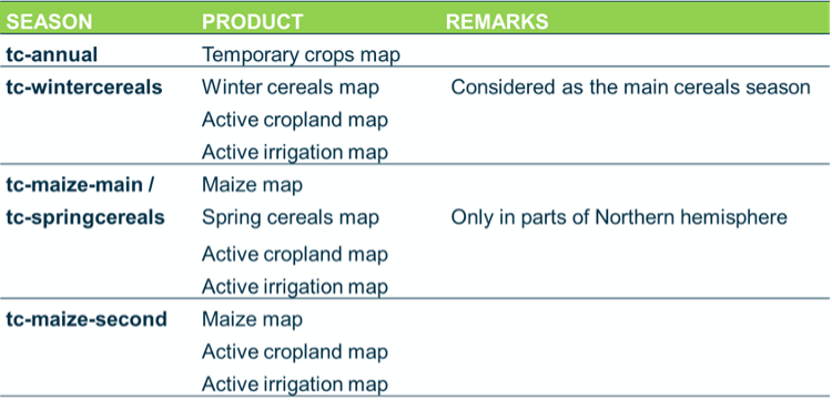 Figure 1: Global WorldCereal temporary crop extent product for 2021, resampled to ~0.004 ° resolution. Each pixel contains a number between 0 and 100, indicating the fractional cover of temporary crops within that pixel.
Aside from these global maps, the WorldCereal project also released a database of publicly available and harmonized in-situ reference data on land cover, crop types and irrigation. Recognising that the availability of good quality in-situ data is often the main limitation in local to global crop mapping applications, this ever-growing database of public data will be key to strengthening capacities on global crop mapping. The public WorldCereal reference database can be consulted through a user-friendly web interface, here.
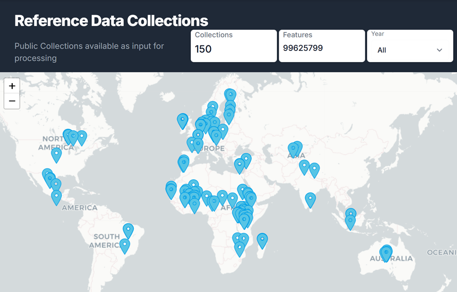 Figure 2: Public and harmonized reference data collections available in the WorldCereal Referece Data Module
A final key component and often limiting factor in global crop mapping is accurate knowledge of the number and timing of growing seasons for each location on Earth. Timing of growing seasons is known to shift dramatically throughout the globe as a consequence of local meteorological and soil conditions, as well as local crop management practices. Therefore, the WorldCereal consortium has released the first global crop calendars for maize and wheat.
Phase II of WorldCereal aims to convert the prototype project into a fully accessible cloud-based processing system, with classification tools that are more generic and customisable for local and regional crop mapping (Figure 3). Additional objectives include demonstrating the system’s accuracy for food security monitoring, expanding community use, and generating updated seasonal global crop type products. The WorldCereal project entered its second three-year phase in December 2023.
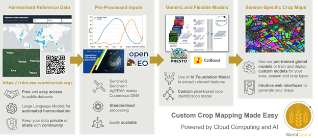 Figure 3: Main features and components of the WorldCereal crop mapping system
The new series of global crop type products will cover maize, winter cereals, spring cereals, wheat, barley, rye, sorghum, millet, sunflower, rapeseed and soybean. On top of this, anyone can use the cloud-based processing system to generate fully customized crop products in terms of area, growing season and crop types. A series of regional use cases in Zambia, Brazil, and India, will be showcasing the potential of this new crop mapping tool in the domain of food security monitoring. Several online and in-person training events are being organized throughout the project, teaching anyone with an interest in crop mapping how the WorldCereal system can be used in local to global crop monitoring applications.
More information on this second phase of the project can be consulted on this webpage. In case you would like to be notified about the project’s progress or upcoming training activities, please subscribe to the newsletter.
Users of the 2021 global WorldCereal products should keep in mind that these maps have been generated at global scale with a single methodology applied over all regions. As such, the accuracy of the map may vary between locations and is especially affected by the amount and quality of available in-situ reference data. Figure 2 of this manuscript shows the spatial distribution of training data for cropland, crop type and irrigation mapping available at the time of generation of the 2021 products. For all produced maps there is also a confidence layer available, to indicate areas where the model is less confident. These confidence layers can be downloaded alongside the actual map products through the link provided above. That said, the global products can be expected to be most useful for countries that do not have their own agricultural monitoring systems in place.
Users of the WorldCereal processing system can freely benefit from the wealth of publicly available and harmonized reference data present in the WorldCereal Reference Data Module. However, users also have the possibility to add their own (private) data to finetune models to boost performance for their area and crops of interest. Sharing your reference data with the WorldCereal consortium to improve future global products is encouraged, yet by no means enforced.
A full overview of the methodology used to produce the 2021 global WorldCereal products can be consulted in this scientific publication.
In short, the global WorldCereal products have been generated based on regional (in case of temporary crops) and global (in case of crop type and irrigation) pixel-based CatBoost classification models, trained using a combination of features derived from Sentinel-2, Sentinel-1 and Landsat 8 satellite data and some ancillary data such as location and a digital elevation model. Products are produced at the end of a certain growing season, which are in turn defined by the global crop calendars.
In the context of the second phase of the project, several improvements are being made to this initial methodology to not only boost model performance, but also increase generalisability of the method towards other crop types. These improvements entail a refinement of the global crop calendars (going beyond maize and wheat) and an improved classification framework employing the powerful Presto geospatial foundation model, co-developed with NASA Harvest, in combination with a light-weight CatBoost approach, providing both robustness and flexibility. Learn more about how Presto embeddings can be computed and used here.
As mentioned in the usage section, uncertainty and accuracy of the 2021 global maps are location-dependent. Areas with large fields and where training data was available, will have higher accuracies than areas with small fields, complex seasonality and little to no training data. Accuracies are also product dependent, where temporary crop extent will normally have a higher accuracy than the irrigation product, the latter being much more challenging.
The validation approach differed from product to product, depending on quality and availability of reference datasets that were not used to train the models and hence available for independent validation. For the temporary crops, global validation results have an overall accuracy of 97.8% with a user’s accuracy for cropland of 88.5% and a producer’s accuracy for cropland of 92.1%. For the maize maps at global scale, a user’s accuracy of 85.8% was reached and producer’s accuracy was 75.5%. For the cereals, the figures are slightly higher with UA 93.6% and PA 77.7%. More details on the validation approach and results can be found in this manuscript.
In addition to the global products for the year 2021 and the new set of global products for a yet to be determined year, expected to be released in 2026, the cloud-based WorldCereal processing system will be fully open, allowing anyone to generate these products for their area and year of interest. The processing system will be available through the Copernicus Data Space Ecosystem, thereby ensuring long-term availability. In addition, the WorldCereal workflows have been on boarded as a service in the European Space Agency’s Network of Resources (NoR) offering, allowing interested parties to apply for ESA sponsorship for generating WorldCereal products.
Technical Characteristics
Spatial resolution: 10m
Geographical coverage: Global
Temporal coverage: 2021, 2024, 2025 (TBC)
Update frequency: No consistent global updates foreseen. The open WorldCereal processing system however allows anyone to generate WorldCereal products for custom region, year and crop types.
Associated Guidance or User Manual
https://esa-worldcereal.org/en
Dataset Download
2021 Global Products: https://vdm.esa-worldcereal.org/
In-situ reference data: https://ewoc-rdm-ui.iiasa.ac.at/
Points of contact for queries
Kristof Van Tricht
WorldCereal Project Manager
Flemish Institute for Technological Research (VITO)
Mol, Belgium
Email: kristof.vantricht@vito.be
Zoltan Szantoi
WorldCereal Technical Officer
European Space Agency
ESA/ESRIN
Frascati, Italy
Email: Zoltan.szantoi@esa.int