Monitoring Coastal Erosion in Senegal
The DE Africa Coastline Service uses CEOS-ARD to support decision-making and contribute to the Sustainable Development Goals and the 2063 agenda of the African Union.
Project Overview
Coastal erosion is a natural phenomenon that occurs due to a combination of the energy produced by waves, wind, and ocean currents. Coastal erosion can also occur due to decreased sediment, increased human activity and global shifts, such as climate change. This, directly and indirectly, affects critical ecological functions in coastal ecosystems.Senegal’s coastline is one of the greatest natural, economic, and cultural resources of Senegal, with invaluable seaside infrastructure, biological resources, and assets. The threat of climate change and increasing human activity has led to a visible effect on the coastline, threatening the sustainability of its ecosystems. The seaside resort of Saly Portudal in Mbour-Senegal was impacted by coastal erosion, and the tourism business was heavily affected as a result. Installation of breakwaters was completed in 2020 to prevent further erosion and massive inflows of sand from the open sea. This has helped tourism, hotels, and fishing activity resume in the area.
Leveraging experience from Digital Earth Australia (DE Australia), experts from the Ecological Monitoring Centre, Centre de Suivi Écologique (CSE), have been working with the Digital Earth Africa (DE Africa) team to validate a tool that enables users to monitor the coastline across the African continent.
Application & Platform
Digital Earth Africa (DE Africa) is a continental-scale Data Cube operating in the cloud. Digital Earth Africa makes Earth observation (EO) data free and accessible, delivering decision-ready products to the African continent. In addition to providing EO data and derived products, it is a processing and analysis environment that provides access to numerous services, tools, and capabilities to allow users to develop applications for research and societal benefit.DE Africa has developed tools such as the Digital Earth Africa Coastlines method and Coastal Erosion notebook, available on the DE Africa Sandbox, to help users monitor coastal erosion in their study area.
The notebooks take advantage of the long-term record of the Landsat series of satellites (Landsat 5-9) to build a full historical view. The notebooks use of methods such as the Normalised Difference Vegetation Index (NDVI), the Normalised Difference Water Index (NDWI) and the Modified Normalised Difference Water Index (MNDWI) allow users to monitor the dynamics of coastlines across the African continent.
CEOS-ARD Usage
The USGS Landsat Collection 2 Surface Reflectance product is endorsed as CEOS Analysis Ready Data (CEOS-ARD). USGS Landsat Collection 2 contains global Level-2 surface reflectance and surface temperature scene-based products from 1982 to present. The data is free and open and distributed via the Amazon Web Service cloud and the Public Dataset Program. From there it is directly accessed by the DE Africa platform (also on AWS infrastructure).Using this CEOS-ARD dataset, coastal erosion can be monitored, and the impacts of local and regional coastal management can be evaluated using historical coastline changes. The data also facilitates modelling of how coastlines respond to drivers of change, including extreme weather events, sea level rise or human development, supporting geomorphological studies of how and why coastlines have changed across time.
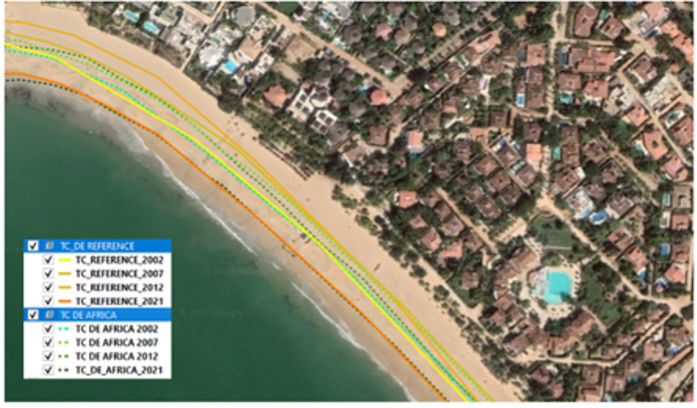
An example of DE Africa coastal dynamic monitoring on a portion of the Saly Portudal coastline. The outlines represent median high tides from 2002 to 2021 from Landsat and other reference images, where lighter colours represent earlier years and darker colours represent more recent years.
Annual evolution of coastal erosion in Saly Portudal between 2002 and 2021. Some areas have suffered a decline and others, an accretion. Recent construction work on the breakwaters is said to have contributed to the reduction of coastal erosion.
Impact
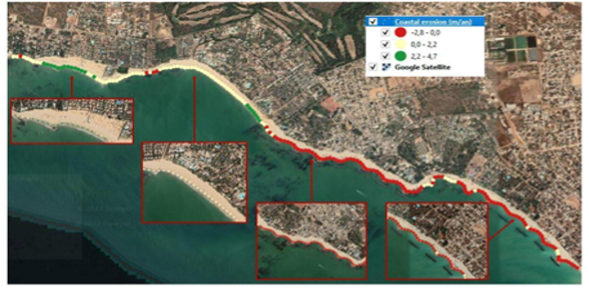
Using USGS Landsat Collection 2 Surface Reflectance CEOS-ARD and tools from DE Africa, the CSE team assessed the coastal erosion and concluded that further losses are estimated at about 3 m per year for the southern part of the seaside resort of Saly Portudal. As a result of the analysis, improved protection facilities, breakwaters, and beach replenishments were carried out, which led to strong accretion and beach expansion of the Saly Portudal portion of the coast.The coastlines generated using the notebooks scripts available in the DE Africa Sandbox were compared with reference data to analyse the coastlines over specific periods and study areas to assess the coastline between specific coordinates. The accuracy of the coastlines extracted from the Earth observation dataset was statistically analysed against specified performance indicators. The level of precision of the results obtained was between 7.5 - 10 m (one-third to one-fourth of a Landsat pixel size of 30 metres) and hence deemed scientifically satisfactory for monitoring coastal erosion at the seaside resort of Saly Portudal and throughout the national territory.
Future Developments
Work to improve the reference data quality is planned to further increase accuracy. The Coastline tools and services are continually developed by DE Africa to provide users with reliable data.The DE Africa Coastline Service, currently in development, will cover the whole African continental coastline. This will enable users to analyse coastal erosion and growth trends annually at both local and continental scales and observe patterns in coastal change over extended periods by mapping historical data and regularly updated data as it is acquired.
The ability to regularly map coastlines at continental scale provides valuable insight into how coastlines change over long time periods, and whether changes result primarily from major events or gradually over time. Such information enables scientists, managers, and policymakers to assess impacts and potentially assist in planning and forecasting of future scenarios. The DE Africa coastline service aims to support decision-making in diverse infrastructure and livelihood-threatening situations and contribute to the Sustainable Development Goals and the 2063 agenda of the African Union.
Technical Characteristics
CEOS-ARD Types: Surface Reflectance
Contributing Missions: USGS Landsat Collection 2
Developing Agency: DE Africa / CSE, DE Australia
Users: CSE
Project website / more info: https://www.digitalearthafrica.org/
Points of contact for queries
Name
Digital Earth Africa
Email