Dataset Description
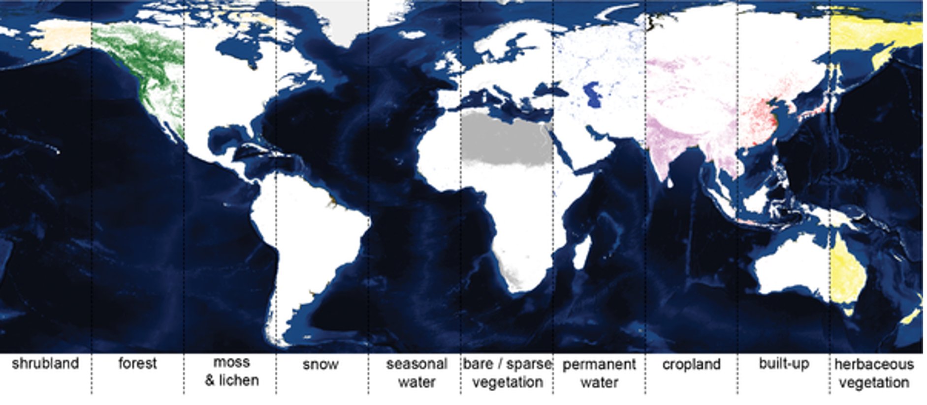
Annual land cover maps representing detailed (100x100 m) spatial information on different types (classes) of physical coverage of the Earth's surface, e.g. forests, grasslands, croplands, lakes, wetlands. Next to these discrete classes, the product also includes continuous field layers or “fraction maps” for all basic land cover classes that provide proportional estimates for vegetation/ground cover for the land cover types. This continuous classification scheme depicts areas of heterogeneous land cover better than the standard classification scheme and, as such, can be tailored for application use. Dynamic land cover maps include transitions of land cover classes over time and hence captures main land cover changes.
Usage
Land Cover and Land Cover change information is used by resource managers, policy makers and scientists studying the global carbon cycle, biodiversity loss and land degradation. Global land cover maps provide a synoptic overview and broad stratification of land cover over large areas a. The broad range of applications including assessing key land cover characteristics and changes related to key IPCC land categories in absence of any quality national or regional data sources for the time frame 2015-2019 and at resolution of 100x100 m.
Methodology
The classification and cover fraction generation a dedicated satellite PROBA-V pre-processing on Sentinel-2 tiling grid (110x110km), with geometric and atmospheric corrections, data cleaning and feature classification based on quality training data (approx. 168 000 points). The global derivation of the product started for the reference year 2015 with land cover map quality reaching now 80 % of overall accuracy at class level 1 on each continent. The use of the Sentinel-2 tiling grid facilitates continuation to switch from PROBA-V to Sentinel-2 that is planned for the next generation maps that will be produced soon annually as part of the continuous global land cover service under Copernicus. There is particular emphasis on the temporal consistency of the annual land cover maps. Specific algorithms were applied to increase the stability of the annual classifications with the effect that differences between the annual maps resulting from inconsistent classifications are reduced while areas of probable land cover change are considered as different classes in the various annual maps.
The production of the annual land cover maps is a key part of the Copernicus global land monitoring service and has a long-term continuity ensured through support from the European Commission and the EU members states.
The method is published: Buchhorn, M. ; Lesiv, M. ; Tsendbazar, N. - E. ; Herold, M. ; Bertels, L. ; Smets, B. Copernicus Global Land Cover Layers—Collection 2. Remote Sensing 2020, 12Volume 108, 1044.
DOI
10.3390/rs12061044
Uncertainty and Accuracy
A rigorous approach is applied for the independent statistical accuracy assessment following the Committee on Earth Observation Satellites (CEOS) Working Group on Calibration and Validation (WGCV) Land Product Validation (LPV) requirements. A global stratification independent of any land cover map and using the Sentinel 2 Universal Transverse Mercator (UTM) grid as a geographic base has been applied to provide more than 21,000 primary sampling units (PSUs) reference pixels for the years 2015-19. Assessments showed that the overall accuracy of the discrete CGLS-LC100m V3.0 Level 1 map reaches 80.6% +/-0.7% for 2015. The maps for the following years (2016-2019) are assessed with around 80.3 - 80.5% overall accuracy. Overall accuracy at continental level is around 80%, with highest accuracy of 83.7% for Asia and the lowest accuracy of 77.6% for North America (for 2015).
At Level 2, when closed and open forests classes are separated, global overall accuracy is 75.4% +/-0.7%. Overall accuracies at global and continental levels show consistency in the quality of the yearly maps. Among the cover fraction layer, snow/ice, built-up, water and lichen/moss fraction maps show lowest errors. The overall accuracy of the change/no-change map (2015-2018) is 99.6%. No-change class covers most of the land area and it is mapped with very high accuracy, while change class is more likely to be committed than omitted (land cover commission error 45.6%, omission error 36%). This reasonable result for change detection is supported by the stability and consistency in the land cover map accuracies for the yearly maps - but highlights that any area change estimation (in the context of GHG inventories) should be using reference data for a stratified area estimation.
Dataset Sustainment
The production of the annual land cover maps is a key part of the Copernicus global land monitoring service and has a long-term continuity ensured through support from the European Commission and the EU member states.
Technical Characteristics
Spatial resolution: 100m
Geographical coverage: Global
Temporal coverage: 2015-2019
Update frequency: Annual
Format: Various formats incl. GEOTIFF, etc.
Data Policy: Free and open
Associated Guidance or User Manual
Product manual
Validation report
Data can be accessed:
https://land.copernicus.eu/global/products/lc
Dataset viewer:
https://lcviewer.vito.be/
Points of contact for queries
Ruben van de Kerchove
Remote Sensing Unit
Flemish Institute for Technological Research (VITO)
Mol, Belgium
Email: ruben.vandekerchove@vito.be
Andreas Brink
European Commission
Joint Research Centre
Ispra, 20127, Italy
Email: Andreas.BRINK@ec.europa.eu