Dataset Description
The Sentinel-3 World Fire Atlas developed by the European Space Agency utilises
Sentinel-3A SLSTR Level 1b data featuring two dedicated channels, F1 and F2 for detecting fire and high temperature events on a global scale during nighttime.
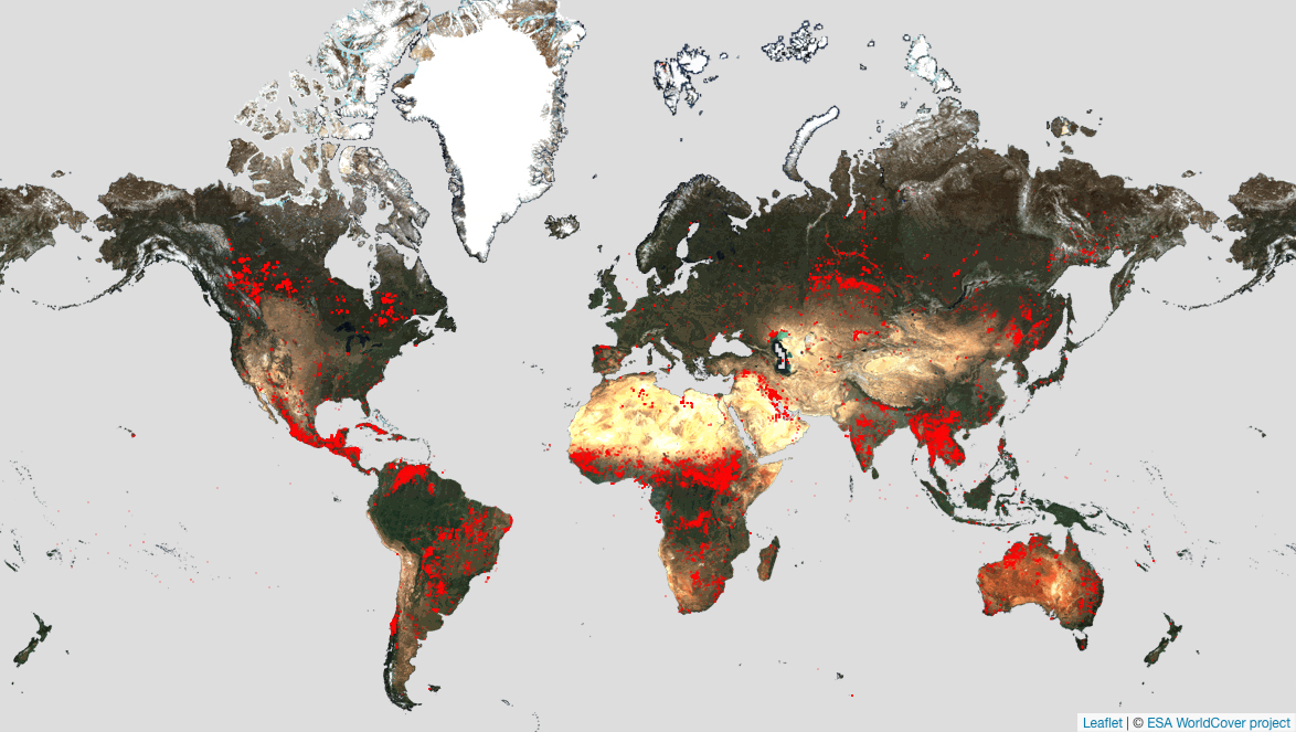 Figure 1:Sentinel-3 World Fire Atlas developed by the European Space Agency
This atlas aims to provide continuity to
ESA ATSR World Fire Atlas, operational from June 1995 to March 2012, while encorporating enhancements from the Sentinel-3 SLSTR instrument.
The processing chain is based on ESA SNAP and GDAL routines. The algorithm derived from a simplification of the work of
Wooster et al. 2012, has been adapted and implemented.
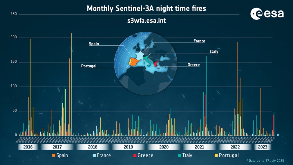 Figure 2:The cumulative monthly fires occurrence graph shows higher peaks for some Mediterranean countries during the last seven years. The highest numbers are reached for Portugal in August 2016 and October 2017, for Italy in summer 2021 and Spain in summer 2022.
Given the increasing occurrence of severe global heatwaves, the Sentinel-3 World Fire Atlas provides up-to-date statistical insights into fire incidents across the world. It consists of two informative sections: the first page offers an overview of single nighttime fire distribution, both at the country and global levels. Concurrently, the second page features an interactive dashboard for user-friendly exploration and analysis of statistics.
Usage
A dedicated
viewer is accessible for free to the users to visualise the resulting detections by location and time. These results are based on Sentinel-3A SLSTR Level 1b Non Time Critical products.
ESA has systematically processed all acquired Sentinel-3A SLSTR Level 1b data from May 2016 up to August 2023. While minor gaps may exist in the S3 World Fire Atlas products due to occasional unavailability of SLSTR data during the mission as reported in the
S3 SLSTR Anomalies and Events document, it's important to note that the S3WFA data is considered statistically robust.
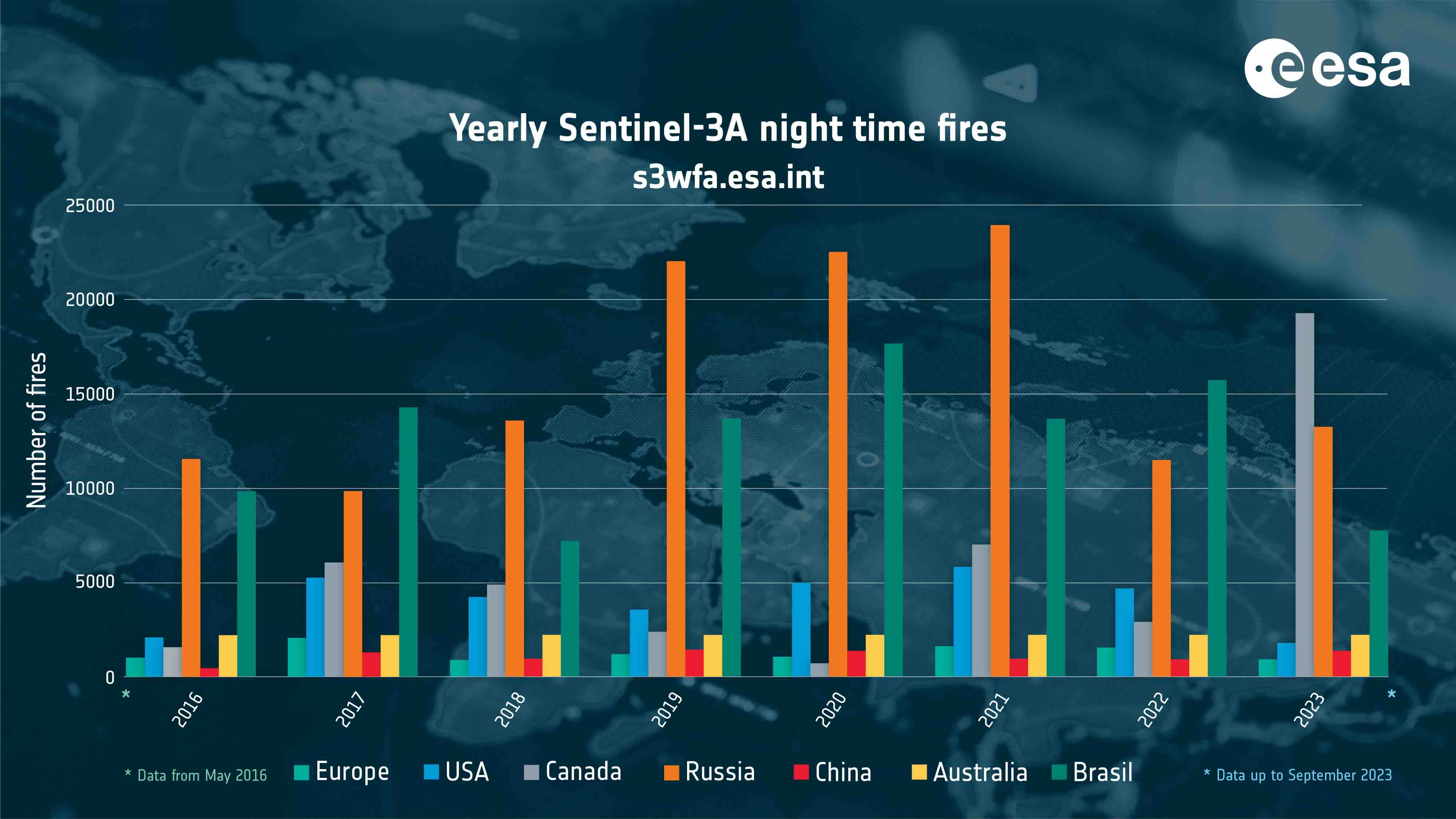 Figure 3: Worldwide active night-time fire detected from May 2016 to July 2024 using Sentinel 3A data
The site also features an
interactive dashboard for user-friendly exploration and statistics analysis.
Technical Characteristics
Spatial resolution: 500 m for visible near-infrared and 1 km for thermal infrared channels
Geographical coverage: Global
Temporal coverage: 2016-onwards
Update frequency: Viewer daily and Dashboard monthly
Associated Guidance or User Manual
https://sentinel.esa.int/web/sentinel/user-guides/sentinel-3-slstr
Dataset Download
https://s3wfa.esa.int/
Points of contact for queries
ESA S3 World Fire Atlas Team
In order to improve the ESA Sentinel-3 World Fire Atlas, feedback from users are welcome by email at:s3wfa@esa.int