 "INFONA is excited about this new opportunity of using satellite information to improve the National Forest Inventory, reduce cost and cover a bigger area of Paraguay. Dr. Sean's Healey methodological approach will take us to a place where we can access areas that have not been sampled in the past.
– Hermelinda Villalba: Director of National Forest Inventory in Paraguay"
Background
Biomass, especially forest biomass, plays a crucial role in sequestering and storing carbon and is a critical component of national Greenhouse Gas (GHG) inventories and the global carbon budget. Mapping aboveground biomass is a priority for space agencies and is highlighted by several new and upcoming satellite missions, including GEDI.
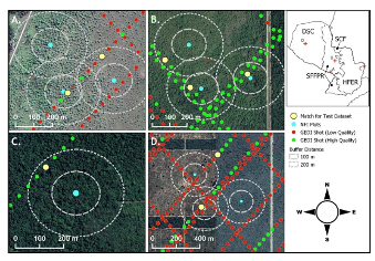 The graph shows how the GEDI shots matched the NFI plots. The circles are the NFI plots, and the blue points are the center of the plot. The dots red and green in the lines are the GEDI shots (low and high quality), and the yellows are the ones they choose to calibrate the model based on the distance from the plot.
Using satellite biomass products seems the natural progression for country Parties when preparing their reports of GHG emissions and removals from the forest sector to the United Nations Framework Convention on Climate Change (UNFCCC). A dedicated international effort coordinated through the Committee of Earth Observing Satellites (CEOS) addresses some of the existing limitations that jeopardize the successful uptake of biomass products by the UNFCCC. A primary objective of the CEOS Agriculture, Forestry and Other Land Use (AFOLU) Roadmap Team, and specifically the Biomass Harmonization group, is to develop the "best available"
harmonized global forest biomass estimates from the next generation of biomass maps as input to the Global Stocktake. This objective is only successfully achieved if the disconnect between producers and users is addressed and we achieve collaboration between EO global biomass monitoring, GHG inventory, and National Forest Inventory (NFI) experts. To support this effort, the USGS SilvaCarbon Program and CEOS collaborate with tropical country officials to utilize the NFI plot data to improve maps' accuracy and usefulness. At the same time, a methodology developed by the US Forest Service assisted Paraguay in improving national estimations and creating a future path to develop emissions factors with satellite information and ground-based data.
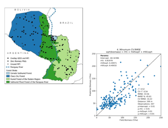
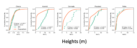
Paraguay has many NFI Plots located within 20 meters of a GEDI shot. The graph below shows the cross-validation of NFI biomass prediction with the GEDI heights data. The analysis shows the difference between the GEDI estimates and the NFI estimates by type of forest.
Datasets Involved
Three datasets were used and analysed to run this model:
- Biomass estimates from the National Forest Inventory in Paraguay.
- The Global Ecosystem Dynamics Investigation (GEDI) attached to the International Space Station (ISS)
- GLAD canopy cover data
Uptake
The
USGS SilvaCarbon program organized a regional workshop in Paraguay to test the model's results using NFI and GEDI data. For this exercise, a group of four countries measured a new plot following the NFI protocol of Paraguay. The results showed that the model underestimated biomass. Still, the level of uncertainty was low enough that this methodology could benefit Paraguay if used in inaccessible areas or to augment the NFI.
Contacts and Further Information
USGS SilvaCarbon Program, Sylvia Wilson: snwilson@usgs.gov
US Forest Service, Sean Healey: sean.healey@usda.gov
US Forest Service, Eric Bullock: ebullock@usda.gov
US Forest Service, Yang Zhiqiang: zhiqiang@usda.gov
INFONA, Hermelinda Villalba: hermevilla_89@hotmail.com
Graphs and Figures provided by Dr. Sean Healey



 "INFONA is excited about this new opportunity of using satellite information to improve the National Forest Inventory, reduce cost and cover a bigger area of Paraguay. Dr. Sean's Healey methodological approach will take us to a place where we can access areas that have not been sampled in the past.
 The graph shows how the GEDI shots matched the NFI plots. The circles are the NFI plots, and the blue points are the center of the plot. The dots red and green in the lines are the GEDI shots (low and high quality), and the yellows are the ones they choose to calibrate the model based on the distance from the plot.
 Paraguay has many NFI Plots located within 20 meters of a GEDI shot. The graph below shows the cross-validation of NFI biomass prediction with the GEDI heights data. The analysis shows the difference between the GEDI estimates and the NFI estimates by type of forest.


