Most of Uganda’s farmers are smallholders who are particularly susceptible to recurrent climatic shocks, particularly drought. To build resilience, the Ugandan Office of the Prime Minister (OPM) sought to design and implement a social safety net programme for the northern Karamoja region. More than 80% of households in the region rely on rainfed, subsistence crops, and they are particularly vulnerable to food insecurity due to poor, sporadic rainfall. With funding from the World Bank, and co-development from the GEOGLAM community, the OPM designed a programme to unlock disaster risk financing that relied on Earth observations (EO) for a fair and transparent process to determine when to release risk financing depending on the severity of crop failure. In this case EO based information provided objective indicators of crop damage and helped benefit 90,405 households under the Disaster Risk Financing (DRF) Programme. Between 2017 and 2020, early financing release saved the government around US $11 million in reactive food aid costs.
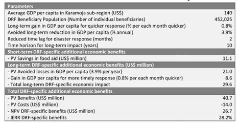 Additional Economic Benefits from DRF Sub-Projects. See Details in The World Bank report: Implementation Completion and Results Report of NUSAF 3
With the implementation of DRF, GoU saved US$2.77 million on emergency food aid during FY16-17 alone - equivalent to total savings of roughly US$11 million in food aid over the four years when the DRF mechanism was triggered (see figure). In addition, the systematic analysis of case studies from Uganda and other countries have also identified significant long term economic impacts, as the timeliness of the relief response to droughts and other disasters might help households avoid selling household productive assets to pay for food.
Datasets Involved
The Global Agriculture Monitoring System (GLAM) is a web-based platform that enables near real-time monitoring of global croplands. Data is provided by NASA using its satellite-based optical sensor for earth and climate measurements: The Moderate Resolution Imaging Spectroradiometer (MODIS) with 250 m resolution. The system automatically aggregates satellite data on vegetation, rainfall, and temperature, which analysts use to visualize and analyze crop conditions. The Normalized Difference Vegetation Index (NDVI) generated by the GLAM provides quantitative information on vegetation conditions, allowing the OPM to predict drought-induced harvest failure and estimate the level of resulting famine several months in advance. The GLAM also allows Uganda’s National Emergency Coordination and Operations Center to produce crop conditions maps (see figure).
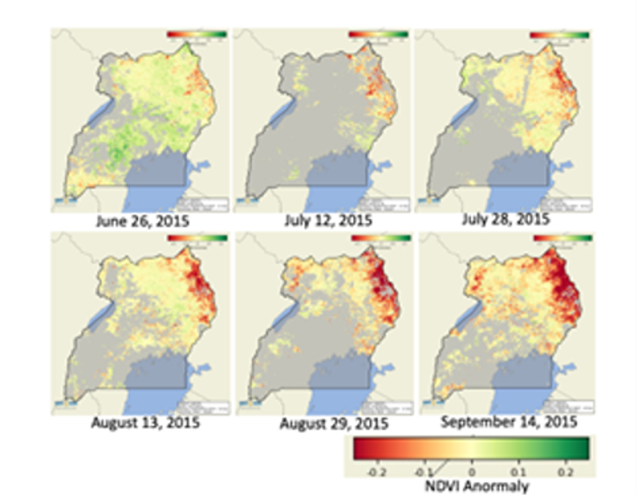 Crop conditions across Uganda, showing deterioration of crop conditions (represented by NDVI) in Karamoja (top right corner) through time (June to September 2015)
User Agencies and Summary of Data Use
The OPM National Emergency Coordination and Operations Center (NECOC) led the Disaster Risk Financing sub-component of the safety net project. NECOC is a 24 hour, 7-days a week central facility for early warning and the coordination of emergency and crisis response and recovery action, supported by a World Bank lending operation. It was established in October 2014 with the support of the United Nations Development Programme (UNDP). An expert from UMD-NASA/Harvest programme worked extensively with the OPM over the project period to co-develop the Disaster Risk Financing mechanism, including providing the analysis to establish the threshold value of the NDVI, setting up the OpenDataKit for in situ data, and providing relevant training to the NECOC team.
Within Uganda, in addition to the leadership and participation of OPM and the District Agriculture Office, national and international partners actively contributed to the project. For the Disaster Risk Financing, a working group was set up and participated in by the
Famine Early Warning Systems Network (FewsNet), the Food and Agriculture Organization (FAO), the World Food Programme (WFP), and Makerere University, with inputs from the Uganda National Meteorological Authority. NECOC assessments are submitted to the Ministry of Finance, Planning and Economic Development for program implementation.
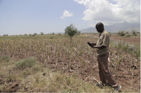 Crop failure in Karamoja, Uganda. Mr. Olinga John, District Agriculture Officer, collecting field data (credit: Catherine Lilian Nakalembe)
Results and Impact
The Uganda Crop Monitor System meets the government’s need for objective evidence to inform rapid, transparent responses to regular famines. Historical data from the GLAM allowed the OPM to set a predetermined NDVI threshold value to trigger a scale-up of the Disaster Risk Financing. When the NDVI values drop below this threshold, OPM officers can estimate how much to invest in public works to provide additional employment opportunities for vulnerable communities. At the end of the growing season, NECOC used the system to calculate the number of households affected by drought, the estimated coverage of the social safety net programme, and the estimated costs for each district. The government used this evidence to make the final financing decisions.
In June 2017, for example, the NDVI value dropped below the threshold in five out of seven districts in Karamoja, predicting widespread crop failure in the harvest season. The government had sufficient time to take proactive action for Disaster Risk Financing. The government released US $4.1million to scale-up public works, benefiting 28,601 households and approximately 150,000 people, more than 50% of whom were women. The approach saved US $2.6 million in costs for food aid, which could be reallocated to target households to strengthen food security.
Between 2017 and 2020, US $14 million of financing indirectly benefited 90,405 households in northeastern Uganda. Over the four years, the early financing release saved the government roughly US $11m in reactive food aid costs. The Earth observation-based early warning system has helped vulnerable households and enabled the government to plan its budget and ensure that resources are utilized efficiently and effectively.
Lessons Learned and Recommendations
While crop failure can have devastating impacts on farmers’ livelihoods and food security, early warning using near-real-time spatially disaggregated EO data gives governments time to prepare, mitigate and respond to a crisis to alleviate loss and damage in a transparent, cost-effective, and efficient manner. Open satellite data, combined with and verified by systematic in situ observations, can enable fast analysis that helps mitigate climate risks in Uganda or any other at-risk countries.
Open data and analyses from the Earth observation community ensure that all governments, organizations, and individuals have access to the data and information they need to report on crop conditions and manage disaster financing regularly. Other countries can use Earth observation-based tools and services provided by GEOGLAM to improve lives, save money, and increase food security. Notably, this methodology and related applications can be efficient when integrated into National Adaptation Plan processes to increase the resilience of the agriculture sector to climate impacts.