Supersites for Satellite Land Product Validation
The validation of satellite-based land products relies heavily on in-situ or fiducial reference measurements (FRMs) collected over an ensemble of globally representative sites, providing consistent, high quality and traceable reference data. These sites must ensure adequate representation of different land cover and ecoclimatic conditions to enable unbiased satellite data validation at global scale. Evolving validation requirements calls for sites with comprehensive characterisation of more variables to verify cross-variable physical consistency and ensure longer term data continuity to sustain validation of current and future operational missions.
In 2016, the CEOS Working Group on Cal/Val (WGCV) Land Product Validation (LPV) Subgroup undertook an assessment to identify a set of ‘supersites’ for land product validation that addressed requirements from the Global Climate Observing System. In 2026, ten years after the original list was published, the list of sites was updated and expanded to accommodate the evolving satellite product needs, emerging Cal/Val initiatives, sensors and sites, and the next generation of satellite missions.

LPV agreed on the following definition for a CEOS LPV supersite to serve the validation of multiple land products:
- Well-characterized site (detailed knowledge of 3D canopy structure and estimation of key land variables) enabling physics-based validation and uncertainty assessment using radiative transfer model simulations.
- Useful for the validation of several land products (at least three).
- Following well-established measurement protocols.
- Spatially representative at the spatial scales relevant to satellite observations.
- Active, long-term operations, supported by appropriate funding and infrastructural capacity.
- Supported by airborne/UAV-based LiDAR and hyperspectral acquisitions (desirable).
- Adherence to CEOS-FRM principles (desirable)
230 candidate sites were identified for inclusion in LPV’s second collection of supersites. The 90 selected sites come from established ecosystem monitoring networks, such as the National Ecosystem Observatory Network (NEON), the Integrated Carbon Observation System, and the Australian Terrestrial Ecosystem Research Network (TERN), as well as satellite validation networks including, Copernicus Ground-Based Observations for Validation (GBOV), the CEOS Radiometric Calibration Network (RadCalNet), and HYPERNETS.
Sites within these networks were each ranked according to how many biogeophysical variables could be validated with a given site, alongside their spatial representativeness, the availability of auxiliary data (e.g., structural data, atmospheric data), and the adopted data access policies. The representativeness of different geographic regions and biomes was also considered, with under-represented biomes being prioritized in the selection process. All information was combined into a score for each site, with those reaching a threshold value achieving LPV’s supersite status.
The geographical distribution of LPV Supersites V2 is presented in the map below with colour code indicating the different biomes. Representativeness in terms of biomes and geographic coverage of each continent is provided in the accompanying bar plots and compared to global distribution. Despite this recent effort, significant geographical gaps remain, particularly in Africa, South America, and Asia, representing a well-known and challenging issue for global satellite validation networks. Furthermore, a more balanced representation of biomes is still needed. Forest biomes (particularly Deciduous Broadleaf Forests and Needle-Leaf Forests) are overrepresented among the supersites, mainly because many of these locations are part of established ecosystem monitoring networks, such as ICOS, NEON, and TERN. Conversely, other biomes, including shrublands, croplands, and especially sparsely vegetated areas, remain underrepresented. These remaining gaps will be addressed in future reviews of the supersites, depending on the availability of new sites and advances in the capabilities of existing ones.
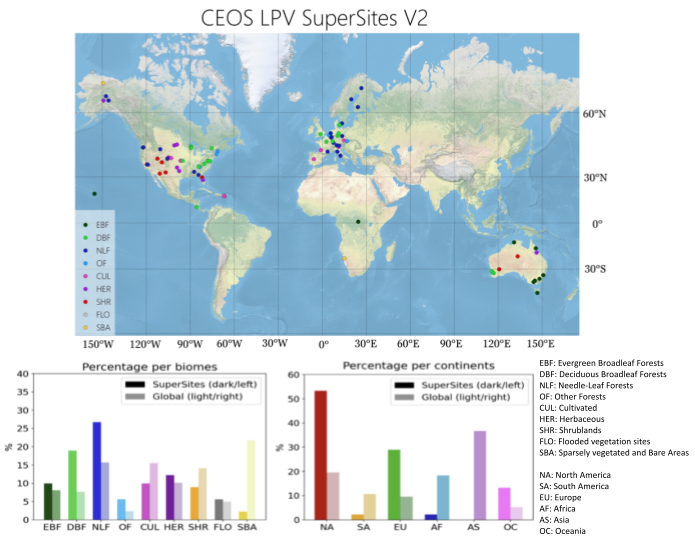
Global distribution of LPV supersites (Version 2, 2026) and their representativeness across biomes and continents (in percentage) compared with the global distribution.
Overall, the LPV Supersites V2 selection supports the validation of satellite-derived land products, testing of retrieval algorithms, and development of validation strategies. The well-characterised, long-term observations collected by these sites enable consistent multi-product evaluation across Earth observation missions, in accordance with QA4EO principles and addressing requirements from global frameworks like GCOS.
More information on the update process for the CEOS LPV Supersites V2 can be found in the QA4EO-2 Technical Note.