Monitoring Greenhouse Gas Emissions with Remote Sensing: Common Practices
The net increase in global temperature since pre-industrial times is primarily driven by the rising atmospheric concentrations of carbon dioxide (CO₂) and methane (CH₄). CO₂ accounts for approximately two-thirds of the total temperature increase, while CH₄ contributes about one-third. However, methane is far more potent as a greenhouse gas, with a global warming potential 84 times that of CO₂ over a 20-year period. Alarmingly, atmospheric methane concentrations are now increasing at rates comparable to or even exceeding those of carbon dioxide. Recognising the critical role of methane in climate change, the Global Methane Pledge was launched at the 26th Conference of the Parties (COP26) in November 2021 by the European Union and the United States. By December 2024, 160 countries had joined the Pledge, which aims to reduce global methane emissions by 30% between 2020 and 2030.
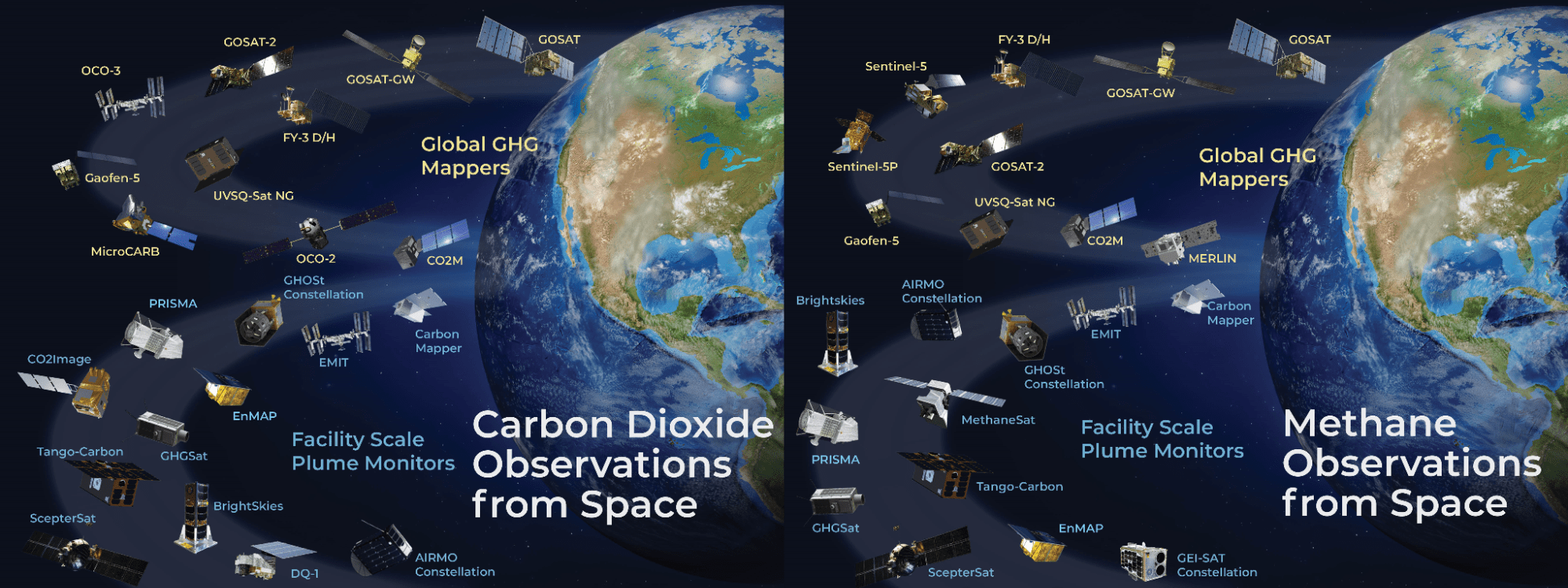
Greenhouse gas (GHG) fluxes occur across a range of spatial scales, from large-scale sources like forests and wetlands (spanning thousands of kilometres) to facility-scale sources such as drilling sites, landfills, and concentrated cattle operations, which operate at metre-level scales. To effectively monitor and quantify emissions at these diverse scales, multi-scale observations using specialised sensors are essential. Satellite remote sensing has emerged as a critical tool for this purpose. Public and commercial satellite systems now provide indispensable data for monitoring CO₂ and CH₄ emissions, enabling policymakers to address climate risk reporting, regulation, and insurance needs. Hyperspectral imagers, in particular, have proven effective for facility-scale monitoring, assessing methane production losses from key sources. Collectively, these facility-scale emissions account for 30–50% of the total global methane budget.
Despite these measurement advancements, the global observing system still lacks the capacity to deliver the high-quality, consistent measurements required to support the Global Methane Pledge fully. To address this gap, CEOS, in collaboration with national agencies and the UN Environment Programme (UNEP) International Methane Emissions Observatory (IMEO), is developing Common Practices For Quantifying, Reporting, Validating, and Assessing Facility Scale Methane Emissions Using Remote Sensing. These guidelines aim to establish a community-accepted methodology for quantifying emissions, ensuring that measurements are robust, reproducible, and actionable. By providing a standardised framework, CEOS is helping guide the growing constellation of dedicated GHG satellites to produce and report data that meet the highest standards.
The Common Practices are outlined in the CEOS/CGMS GHG Roadmap, which describes the implementation of a constellation architecture for monitoring CO₂ and CH₄ from space. The roadmap focuses on maximising the quality, utility, transparency, and continuity of space-based GHG products, making them improved and fit-for-purpose for stakeholders. Designed for both data producers and users, the Common Practices encompass guidelines for data processing (L0–L4), validation, and a comprehensive quality assurance framework. The current priority is on facility-scale methane emissions, with a draft version undergoing refinement throughout 2025. Future efforts will address the Global Methane Pledge, as well as carbon dioxide emissions and wide-area measurements. The ultimate goal is to ensure that space-based methane measurements are utilised to their full potential in combating climate change.