February 2023 Türkiye/Syria Earthquakes: Kahramanmaraş Event Supersite
In the hours and days following the recent devastating earthquakes around the Türkiye-Syria border, the CEOS Working Group on Disasters (WGDisasters) has worked to ensure Earth observation data is made available for recovery efforts. WGDisasters is a key partner in the Group on Earth Observations (GEO) Geohazards Supersites and Natural Laboratories (GEO-GNSL) Initiative, which has established a Supersite for the Kahramanmaraş Event. The Supersite is coordinated by the Kandilli Observatory and the Istanbul Technical University, which provide scientific information to the main Turkish response agency – AFAD.
The East Anatolian Fault Zone (EAFZ) forms a plate boundary (approximately 600 km) between the Arabian and Anatolian plates. Its southern extension connects to the Dead Sea Fault Zone (DSFZ) and creates a triple junction between Adana block, Anatolian and Arabian plates at Kahramanmaraş. Its northern tip connects with the North Anatolian Fault Zone and creates another triple junction between Arabia, Anatolia and Eurasian plates at Karlıova.
This geometry creates the potential for large and devastating earthquakes, as seen in February 2023.
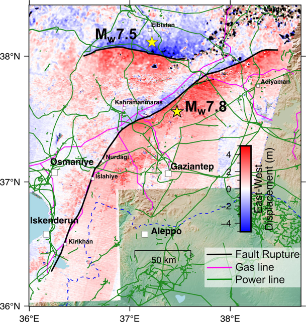
In the early morning of 6 February 2023 (4:17 a.m. local time), a magnitude 7.8 earthquake occurred on the East Anatolian fault resulting in massive destruction and loss of life in south-eastern Türkiye and northern Syria. The region was struck again about 9 hours later by another earthquake of magnitude 7.7, and a third earthquake of magnitude 6.4 hit the region two weeks later, on 20 February 2023.
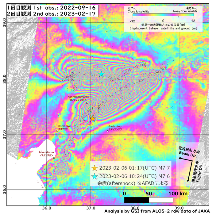
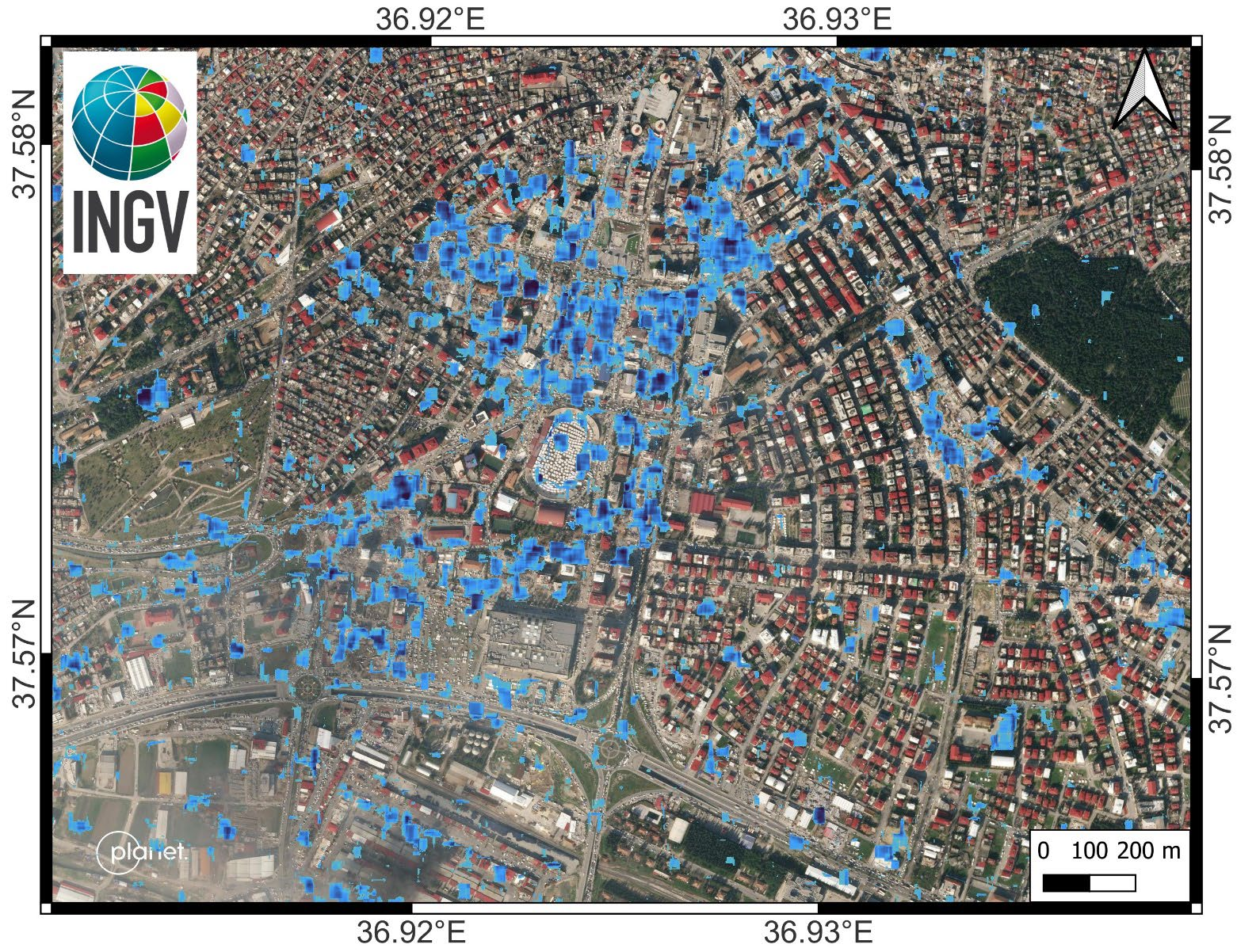
Due to the large area affected by the earthquakes, the use of Earth observation data is fundamental to assess the physical characteristics of the 450 km-long rupture and monitor the evolution of the Kahramanmaraş disaster impacts. Earth observations provide crucial situational awareness information for important decisions making during the response phase. The co-seismic ground displacement estimated from EO data (e.g. Sentinel 1 and 2) using interferometric SAR (InSAR) and pixel tracking techniques is used by scientists to locate the surface ruptures of the earthquakes and calculate inversion models of the seismic sources. These models are needed to map how much stress is transferred onto nearby faults, possibly leading them to rupture in the following days/months. The results are immediately shared with the General Director of Earthquake and Risk Reduction at AFAD and to those who are mapping the ground deformation in the field. The same data are used to identify triggered fault segments that may pose further hazard to the region. Frequent image acquisitions are required to monitor the evolution of the disaster impacts, including incremental building damage, landslide movements, infrastructure and dam stability, and postseismic deformation.
GEO-GNSL is organised as a voluntary international partnership which aims to improve geophysical scientific research and geohazard assessment, promoting rapid and effective uptake of scientific results for enhanced societal benefits in Disaster Risk Reduction (DRR). The initiative focuses on areas with important scientific problems and high risk levels: the Supersites and the Natural Laboratories. GNSL coordinates a network of thirteen permanent supersites and one natural laboratory, alongside event supersites, which are established in response to earthquakes or volcanic eruptions of particularly relevant magnitude or impact, such as Kahramanmaraş. The Kahramanmaraş Supersite Science Page reports contributions from the scientific community, and is used to share multidisciplinary research results in a rapid and comprehensive way with the Supersite coordinators, who can use this information to support the agencies involved in the disaster response phase.
The EO data access page, provides information on relevant openly accessible satellite imagery, including those made available by the CEOS agencies, and those contributed by other public and commercial providers to support the emergency response.
WGDisasters has mobilised its agencies to provide free and accessible data for DRR and scientific use through the Event Supersite, including stripmap images from Argentina’s SAOCOM, Italy’s COSMO-SkyMed, and German TerraSAR-X satellites. JAXA has also supported the emergency response, with analysis on the crustal deformation detected by ALOS-2, while ESA and the European Commission activated the Copernicus Emergency Mapping Service (CEMS). The International Charter on Space and Major Disasters was also activated for the event, with data products made available from many CEOS Agency missions, alongside commercial data.
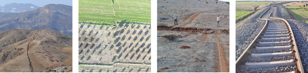
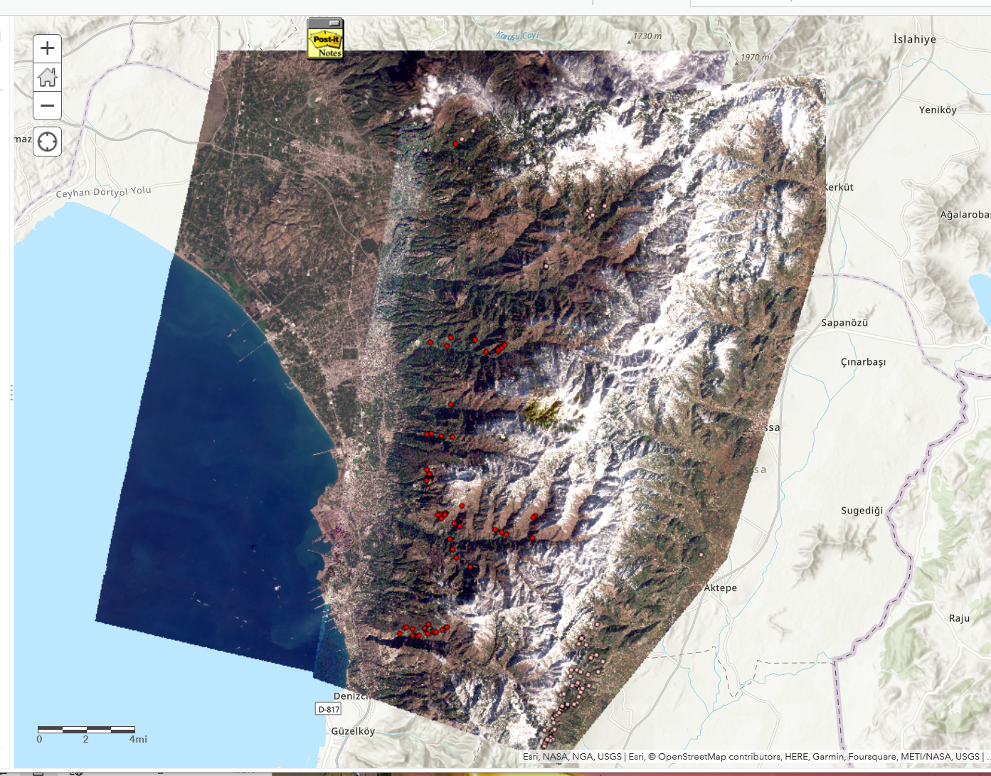
These photos show the surface rupture along the fault line, taken by the ITU field investigation team lead by Prof. Serdar Akyüz.
Thank you to Stefano Salvi, Chair of GEO-GNSL, and Ziyadin Cakir, Professor of Geological Engineering at ITU, for co-authoring this article.