Open Data for Impact
This is the first in a series of three articles on Open Data that has been prepared as a contribution to the 2021 NASA CEOS Chair theme “Space-based Earth Observation Data for Open Science and Decision Support”.
- Open Data for Impact (this article) looking at the origins of data sharing principles, and satellites and open data.
- Outcomes of Open Data Policies discussing some projects that have resulted as a consequence of the availability of open data.
- Looking Forward: The Future of Open Data examining the future direction of open data for Earth observation, including CEOS Agency missions.
Data Sharing Principles
One of the first acts of the Group on Earth Observations (GEO) in February 2005 was to adopt a set of Data Sharing Principles around the idea that, “the societal benefits of Earth observations cannot be achieved without data sharing”. In line with this, three Data Sharing Principles were articulated:
- There will be full and open exchange of data, metadata and products shared within the Global Earth Observation System of Systems (GEOSS), recognizing relevant international instruments and national policies and legislation;
- All shared data, metadata and products will be made available with minimum time delay and at minimum cost; and,
- All shared data, metadata and products being free of charge or no more than cost of reproduction will be encouraged for research and education.
Since they were first adopted in 2005, these Principles have been reaffirmed by GEO in 2015, through ongoing GEO activities, as well as by a number of broader national and intergovernmental activities and statements of policy. This includes the 2009 launch in the US of data.gov built around the principles of open government, and that, “Opening government data increases citizen participation in government, creates opportunities for economic development, and informs decision making in both the private and public sectors.” In 2012, the European Union Open Data Portal (EU ODP, data.europa.eu) was established, and in 2013 the G8 Open Data Charter and Technical Annex affirmed that, “Open data sit at the heart …” of a global growth movement, stressing amongst other things the idea of, “Open Data by Default”.
As the GEO Participating Organisation responsible for the coordination of the GEOSS space segment, CEOS and its Working Teams have long supported GEO’s Data Sharing Principles, and indeed supported open data policies more broadly. CEOS Agencies have been at the forefront of not just promoting open data, but also acting by providing key open datasets and implementing open data policies which have contributed greatly to the unlocking of the potential of satellite Earth observations.

Image of the Earth from TIROS 1 [Image NASA]
Satellites and Open Data
Since the first images taken by the TIROS-1 satellite in 1960, space-based Earth observations have played an important and expanding role in many aspects of human society. By providing global synoptic views, satellite observations are central to weather and marine monitoring and forecasting which supports science, economic activity, and helps to safeguard human life. Satellite observations related to meteorology have long been shared through mechanisms established by the UN’s World Meteorological Organisation (WMO), and these mechanisms function efficiently to facilitate the exchange of data between members.
Beyond weather forecasting, satellite observations have become crucial sources of information across a very broad and diverse range of societal, scientific, and economic domains. These observations have greatly increased our understanding of the Earth system, and through increasingly deep archives (in somes cases dating back to the 1970’s) provide a valuable objective baseline.
The breadth and depth of observations is captured by the number of measurements included in the CEOS Database. At the time this article was written, the Database identifies 192 measurements organised across major domains, and more than 3,600 cases where instruments capture observations in support of those measurements.
CEOS and CEOS Agencies have sought to promote the policy relevance of these observations by organising around broad thematic areas, for example monitoring of changes to the Earth’s climate (Paris Agreement), changes in ice sheets and extent, in support of challenges such as the United Nations Sustainable Development Goals and the Sendai Framework for Disaster Risk Reduction 2015-2030.
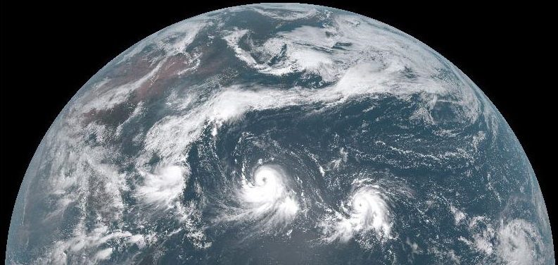
Tropical Storms viewed from Japan’s Himawari-8 in 2015 [Image Himawari-8]
Availability of open data is central to maximising the impact of satellite Earth observations across all of these areas.
While open flows of data had been common in the meteorological community for a number of years, in the early-2000’s, CEOS Agencies expanded the open sharing of satellite EO data. The 2002 launch of NASA’s Terra and Aqua satellites, with the broad dissemination of a wide variety of products via the internet has made them one of the the most cited EO missions in academic literature. In January 2008, the partners in the Landsat Program, NASA and USGS, signed the Landsat Data Distribution Policy ushering in a new era of satellite data access, requinging USGS to provide, “…selected satellite data products for retrieval via the Internet at no charge to users.” This overlapped with the gradual opening of the CBERS archive (Brazil, China), which started in 2004 (Brazil only), and then became available globally in 2010.
Since the early 2000’s, there has been a steady improvement in the spatial, spectral, and temporal revisit of open data flows. In 2014 the first Copernicus satellite – Sentinel-1 A – was launched. This was the first in what is currently eight Sentinel satellites providing optical, C-band radar, ocean colour, temperature and altimetry, and atmospheric composition on an open basis. Notably, Sentinel-1 A and Sentinel-1 B represent the first open radar imager data.
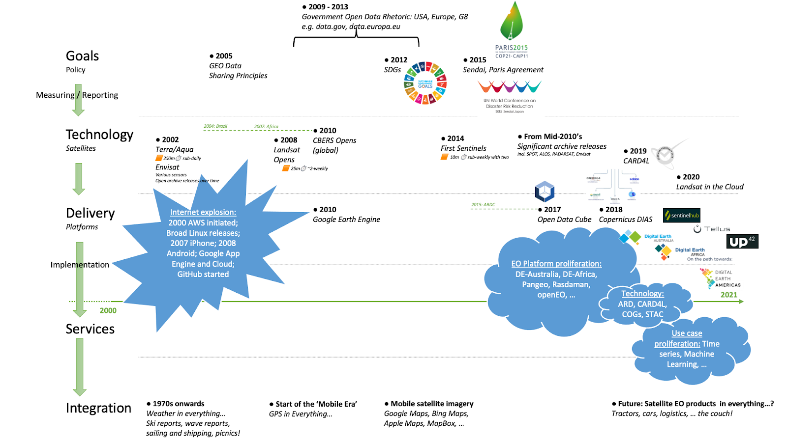
Open Data Timeline: Policy, Technology, Delivery, Services and Integration