OSVW-VC: What Have They Been Up To?
This article is the fifth in a series of seven articles describing the role and work of the CEOS Virtual Constellations. The series of articles is as follows:
- Atmospheric Composition (AC-VC)
- Land Surface Imaging (LSI-VC)
- Ocean Colour Radiometry (OCR-VC)
- Ocean Surface Topography (OST-VC)
- Ocean Surface Vector Wind (OSVW-VC) (this article)
- Precipitation (P-VC) (coming soon)
- Sea Surface Temperature (SST-VC) (coming soon)
The CEOS Virtual Constellations (or ‘VCs’) are defined as “a set of space and ground segment capabilities operating together in a coordinated manner, in effect a virtual system that overlaps in coverage in order to meet a combined and common set of Earth observation requirements.” The interim goal of each VC is to demonstrate the value of a collaborative partnership in addressing a key observational gap, while the end goal is to sustain the routine collection of critical observations. For more on what the VCs are in general, see the process paper.
The Ocean Surface Vector Wind Virtual Constellation (OSVW-VC) exists to foster the best quality ocean surface vector wind data for applications in short, medium, and decadal time scales in the most efficient manner through international collaboration, scientific innovation, and rigour.
OSVW-VC serves as the formal link between the CEOS community and the International Ocean Vector Winds Science Team (IOVWST), who have been working since 2008 to make the best quality scatterometer wind data available, based on state of the art scientific and calibration/validation developments. The OSVW-VC showcases those developments and their applications to the CEOS community, which helps support the IOVWST, particularly with regard to calibration, validation and outreach efforts.
The virtual constellation requires at least 3 scatterometers in orbits designed to roughly meet WMO requirements (observations every 6 hours), with one instrument in a non-sun-synchronous orbit for sampling the diurnal cycle, better mid-latitude sampling and to provide inter-calibration. OSVW-VC have been discussing the observing system requirements for better accuracy and resolution, in both space and time. Observation requirements vary greatly depending on the spatial and temporal scales of phenomena that need to be captured in a model, and sampling requirements in space and time are driven by the need to capture the variability.
Spaceborne scatterometers (C- & Ku-band) are the trusted reference standard to provide global ocean surface wind vector data. Other remote sensing techniques have demonstrated varying capabilities at retrieving ocean surface winds, including microwave radiometers (Multi-frequency, Polarimetric and L-band), Synthetic Aperture Radar (SAR), GNSS-R and high frequency radars (regional coverage but frequent temporal refresh).
Ocean wind vector data is used for weather forecasting, climate observing and analysis (seasonal, inter-annual and longer time scales), ocean dynamics, among other applications.
OSVW-VC works with the CEOS Working Group on Calibration and Validation (WGCV), where a working team has been formed to consolidate standards and metrics, and datasets have been shared intercalibration and consolidation of standards and metrics. They also work within the Coordination Group for Meteorological Satellites (CGMS) Ocean Surface Wind Task Group (OSW TG), to coordinate actions and recommendations between GSICS (Global Space-based Inter-Calibration System), CEOS, the IOVWST and other relevant stakeholders.
The biggest challenge OSVW-VC is currently facing is differentiating products that are developed to retrieve the actual winds versus products that are tuned to infer the maximum wind speeds. There are many competing technologies making various claims to be able to provide ocean wind products, and OSVW-VC needs to be able to objectively evaluate these technologies based on a solid foundation of data and facts.
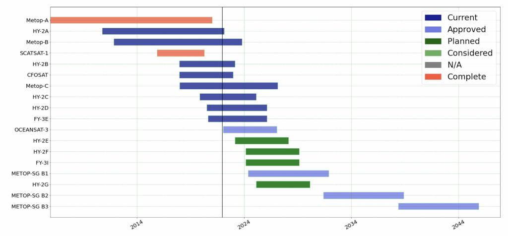
OSVW missions, as produced using the CEOS Database.