Sentinel-6 Michael Freilich: the new Reference Altimetry Mission
Following the project scientists’ recommendation during the last Ocean Surface Topography Science team meeting, on 24 March, CEOS Ocean Surface Topography Virtual Constellation (OST-VC) members declared Sentinel-6 Michael Freilich as the new Reference Altimetry Mission for the worldwide altimetry constellation.
For more than four decades, scientists have used satellite-based instruments known as radar altimeters to monitor ocean surface topography—the shape and height of the ocean’s peaks and valleys. Radar altimeters continually send out pulses of radio waves (microwaves) that bounce off the surface of the ocean and reflect back toward the satellite. The instrument calculates the time it takes for the signal to return, while also tracking the precise location of the satellite in space. From this, scientists can derive the height of the sea surface directly underneath the satellite.
Known to the science community as “reference missions,” these altimetry satellites have been making standardised measurements of the fluctuations of sea level near and far. They provide a unified ocean topography record and the equivalent coverage of a half-million tide gauges.
Sentinel-6 Michael Freilich (also known as Jason-CS) provides continuity for the previous reference series of Missions, Europe & USA’s Jason series: Jason-1 launched in 2001, Jason-2 in 2008, and Jason-3 in 2016. Sentinel-6 Michael Freilich launched in November 2020, with a radar altimeter package to continue the high-precision, low-inclination altimetry missions of Jason-2 and -3, becoming the reference mission for all other complementary high-inclination missions such as SARAL, HY2 and Sentinel-3. It will carry on the long-term record of high-precision measurements of the global sea-surface topography for the marine and climate user community.
Following the completion of Sentinel-6 instrument cross-calibration with Jason-3, achieved during the tandem flight phase, and similar to the strategy adopted previously with Jason-2 at the time when Jason-3 became the Reference Altimetry Mission, Jason-3 will be relocated into an interleaved orbit with Sentinel-6. This will maximise the temporal and spatial sampling provided by the two altimetry missions.
The series of manoeuvres to place Jason-3 into interleaved orbit began on 7 April 2022. During the duration of the manoeuvres, the Jason-3 altimeter will be switched off. The provision of Jason-3 altimetry products to users will resume on 25 April 2022, when Jason-3 will already be in interleaved orbit with Sentinel-6. From April 7, Sentinel-6 Michael Freilich is considered the Reference Altimetry Mission.
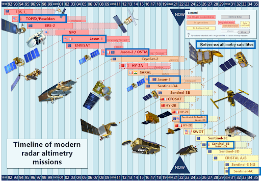
Timeline of modern radar altimetry missions. The reference altimetry satellites are highlighted with a blue box.