SRIX4Veg: Second Workshop
The Surface Reflectance Intercomparison eXercise for Vegetation (SRIX4Veg) project represents a joint effort between ESA, CSIRO, USGS, DLR, ASI, and Geoscience Australia to test user-based differences in UAV-based surface reflectance fiducial reference measurements used for the validation of surface reflectance satellite products. The project is endorsed by the CEOS Working Group on Calibration and Validation (WGCV), and aims to ensure consensus on UAV-based surface reflectance validation good practice protocols. The project is conducted in the framework of the European Space Agency’s (ESA) FRM4Veg (Fiducial Reference Measurements for Vegetation) initiative with the local support of UCLM (University of Castilla La Mancha) and ITAP (Agronomic Technical Institute of Albacete).
In July 2022, the SRIX4Veg participants travelled to Las Tiesas Experimental Farm in Barrax, Spain, with the goal of creating a community agreed good practice protocol for collecting UAV-based surface reflectance data for satellite product validation. The goal was to determine the expected deviations in surface reflectance reference data collected from UAVs operated by different groups under the same conditions and over the same area.
Ahead of the field trip, the participants met online in March 2022 at the first SRIX4Veg Workshop, to discuss the goals and purposes of the project, alongside planning for the exercise. Now, following the collection of field data, the team is planning a 2nd workshop, this time in person at ESA ESRIN (Frascati, Italy), on Thursday 23rd and Friday 24th November, 2023.
The aim of the second workshop is to:
- present to the community the results from the SRIX4Veg activity in Spain during summer 2022
- gather feedback from the community and shape the good practice protocol for surface reflectance validation from UAV-mounted hyperspectral imagers
The first day will provide a recap of the activity, results from the experiments and lessons learnt. The second day will be dedicated to shaping the good practice protocol through discussions and feedback. A detailed agenda will be released closer to the time.
More information on the upcoming workshop can be found on the website, and interested participants are invited to register here.
SRIX4Veg July 2022 Field Campaign
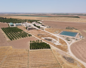
Las Tiesas Experimental Farm, Barrax, Spain. Credit: SRIX4Veg
The Las Tiesas Experimental Farm is located near Barrax, Spain, was established in 1999, and is managed by the ITAP (Agronomic Technical Institute of Albacete). The site meets the main Fiducial Reference Measurement (FRM) requirements for satellite validation purposes, including flat, large, uniform land-use units representative of different crop types, good accessibility by road, good connection with site owners and research, and 90% likelihood of clear skies in July.
Seven teams took part in the exercise, hailing from NRC (National Research Council Canada), RIT (Rochester Institute of Technology), NERC (Natural Environment Research Council), NPL (National Physical Laboratory), WUR (Wageningen University and Research), GFZ (German Research Centre for Geosciences) and GEO-K s.r.l.. The instruments and payload were each restricted to certain specifications:
- Instruments were required to have contiguous spectral bands within the 400 nm – 1000 nm spectral range
- Spectral resolution no greater than 10 nm
- Maximum UAV and payload weight no greater than 25 kg
The exercise was conducted via two experiments. In each, the goal was to collect data that would most closely match with Sentinel-2 (S2) such that comparison across the different teams could take place. Note that the goal was not to validate S2. The UAV flights were performed over a corn field covering an area of 60 m x 60 m (consistent with 3 x 3 pixels at 20 m resolution of S2) to measure the Hemispherical-ConicalDirectional Reflectance Factor (HCDRF). The take-off and landing locations were the same for all the teams, and each participant flew back-to-back in a round robin experiment.
The first experiment adhered to an initial draft protocol developed by the NPL team, and was planned based on a typical S2 satellite overpass. The second experiment allowed each team to collect data according to their own approach but with the goal of producing validation data which could be used to validate S2. In total, 52 flights were completed across the 3 days of measurements.
During the exercise, a HYPERNETS system was also installed on a temporary mast to test the instrument and to provide field data to support the exercise. The instrument took surface reflectance measurements over the corn field every half hour between 8 am and 6 pm each day.
More details can be found here.
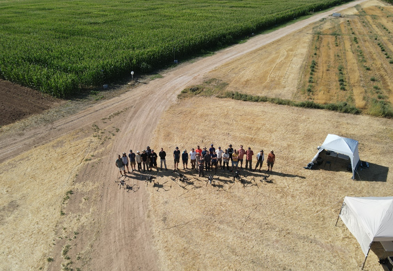
SRIX4Veg Participants in the field.