Use Cases for Climate Monitoring from Space
The Committee on Earth Observation Satellites (CEOS) & Coordination Group for Meteorological Satellites (CGMS) joint Working Group on Climate (WGClimate) has been collecting Use Cases to demonstrate the value of Earth observation satellites for societal benefit and decision making. The work started with an initial set of use cases published in 2015, and the new collection now includes 15 use cases from across the world.
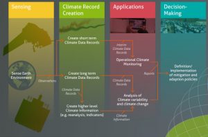
The Climate Monitoring Architecture for space-based observations
The Strategy Towards an Architecture for Climate Monitoring from Space (the ‘Architecture’), which was developed by WGClimate in consultation with the World Meteorological Organisation (WMO), responds to the needs and requirements of the Global Climate Observing System (GCOS). The Architecture focuses on satellite observations for climate monitoring from space and the need for an international architecture that ensures delivery of these observations over the time frames required for analysis of the Earth’s climate system. Following the publication of the Climate Monitoring Architecture, WGClimate worked to document current capabilities through a systematic and granular assessment of the production of the Thematic Climate Data Records at the level of individual agencies, ultimately producing an Inventory of the Essential Climate Variables (ECVs).
The Use Cases compiled by WGClimate build on the Climate Monitoring Architecture and the ECV Inventory, with the goal to validate the top-down information flow outlined in the Architecture with a bottom-up approach, ensuring traceability from usage to space-based observing systems. The project also demonstrates the value of Climate Data Records (CDRs) for decision/policy making and optimises their usage in applications relevant for climate services and science.
The current use cases can be found at climatemonitoring.info/use-cases. If there are any further examples of climate data records used for societal benefit, please consider submitting via the template. For more information and questions about the Use Cases, please contact Dr. Wenying Su (Wenying.Su-1@nasa.gov).
A short summary of each of the current use cases is provided below.
Soil Moisture estimation over agricultural fields using SAR (North America)
Satellite observations will be integrated with ground sensor data to generate field-scale soil moisture maps over alfalfa fields. The surface soil moisture information will be integrated into the CropX’s hydrological model to generate root-zone soil moisture maps. Once the data from NISAR are available, the soil moisture estimation models will be expanded to the crops with the higher biomass.
Marine Climate Change and the impact on coastal regions (Mozambique, Madagascar, Mauritius, South Africa)
Mozambique, Madagascar, Mauritius and South Africa have significant coastal populations whose lives and economic security are highly vulnerable to the consequences of climate variability and change. Mozambique, Madagascar, and Mauritius are highly exposed to surges associated with cyclones, and all have economically important coastal ecosystems sensitive to climate change. Access to enhanced regional information on coastal risk factors (sea level, wave and wind extremes) improves capability to develop plans to protect coastal communities and safeguard economic activity. This project is delivering access to information on sea level rise, storm surge, wind speed, and wave heights derived from satellite altimetry and validated with local in-situ measurements.
Seasonal forecasts for food security analysis in Kenya
SERVIR is a joint NASA-USAID program that uses satellite data to improve environmental decisions around the world. SERVIR has helped the government of Kenya to use satellite and satellite-derived modelled data for food security analysis through digital food balance sheets. This information enables Kenya’s Ministry of Agriculture, Livestock, Fisheries, and Cooperatives to focus on areas where financial and food aid is acutely needed.
Impact of wildfires on air quality in Sub-Saharan Africa (SSA)
Frequent wildfires, especially during prolonged dry conditions such as during El Niño events, may result in the disturbance of forest and savannah ecosystems. Drier conditions influenced by low latent heat flux, low precipitation and low relative humidity aid in the intensity of the fire. This study necessitates better regional fire management and air quality control strategies and enforcement to combat the devastating effects of wildfires, to preserve endangered species and habitats, promote sustainable land management, and reduce greenhouse gas emissions.
Developing a top-down carbon dioxide and methane inventory to aid the global stocktake (Global)
Comprehensive, spatially-resolved global carbon dioxide and methane budgets are developed from space based atmospheric measurements to support the UNFCCC Global Stocktake. These top-down carbon dioxide and methane budgets complement the bottom-up national inventories by providing an integrated constraint on net emissions from all sources and sinks at national and sub-national spatial scales. The primary objective of the pilot atmospheric budgets is to start a conversation to establish the utility and best practices for the use of top-down atmospheric budgets with bottom up inventories in future Global Stocktakes.
Space-based Weather and Climate Extremes Monitoring (SWCEM) (Southeast Asia & Western Pacific Ocean)
Space-based rainfall estimates are valuable for persistent heavy rainfall and drought detection and monitoring with more than 20 years of climatology for anomaly analysis, especially for regions where rain gauge observations are limited or unavailable. The Space-based Weather and Climate Extremes Monitoring (SWCEM) project was implemented in WMO Regional Association II and Regional Association V, covering South-East Asia and the Western Pacific Ocean area. The JAXA GSMaP and NOAA/CPC CMORPH rainfall estimates provided by the SWCEM are used in WMO Regional Climate Centres and ASEAN Specialised Meteorological Centre (ASMC). In addition, drought monitoring in Australia utilising the JAXA and the NOAA products was noted in the WMO Statement on the State of the Global Climate 2019.
Solar Irradiance Specification for Attribution of Natural Earth-system Variability (Global)
Solar irradiance variability drives natural Earth-system change on time scales from months to millennia. The natural Earth-system response of fundamental climate parameters to solar irradiance variability has been identified in statistical analyses of observations and in physical climate model simulations. The reliable detection and attribution of natural Earth-system variability is therefore key to isolating anthropogenic-drive change.
Hail Risk Assessment Using Space-Borne Remote Sensing and Reanalyses (South Africa)
Of the three primary severe convective storm hazards (hail, tornadoes, and straight-line wind gusts), hail is the costliest hazard for the insurance industry, generating about 70% of average annualised losses. Hail catastrophe models (CatModels) are used by reinsurance to estimate risk to an insurer’s portfolio. CatModels are developed with climatologies that define hail storm frequency and severity, but hail climatologies are difficult to derive over developing nations without hail reporting or climate-quality weather radar observations. This NASA Applied Sciences Disasters program project combines reanalyses (e.g. ERA-5 and MERRA-2) with geostationary and low-Earth-orbiting (LEO) imager data to develop new hailstorm climatologies and regional CatModels.
Cholera Risk and Climate Observations (Northern Indian Ocean)
Key climate data records of ECVs for forecasting cholera risk have been identified and used to develop an outbreak risk model. The case highlights the importance of including socio-economic data and extreme events for further developments. A web portal prototype has been developed as a proof of concept, and it has been presented to the UNFCCC COP26 Earth Information Day.
Relationship between land surface albedo and precipitation in the Sahel region (Africa)
Land surface albedo is a key forcing parameter for the climate system controlling the radiative energy budget. The objective of this use case is to assess the relation between an albedo change and a different precipitation regime in the Sahel region. The Geostationary Surface Albedo (GSA) algorithm jointly developed by EUMETSAT and the Space Applications Institute of the Joint Research Centre (JRC) of the European Commission has been chosen. GSA has been also selected for the generation of a GEO-ring albedo within the WMO SCOPECM initiative (Lattanzio et al. 2012).
Enhancing Adaptation and Resilience against multi-hazards along West Africa’s Coasts (EARWAC)
The EARWAC Dashboard brings together extant data, including from the European Space Agency Climate Change Initiative (ESA CCI), and other local indicators from multiple stakeholder sources; and shows information on coastal multi-hazards. The dashboard could support climate adaptation priorities, decision-making, and alerts/preparedness for coastal multi-hazards across West African coastal cities. The Coastal Flood Vulnerability Index (2020 to 2022) during the rainy season falls between severe, critical, and very critical for most parts of coastal West Africa, especially the southernmost fringes, with tens of millions of people at-risk. Normal and extreme flash floods over the region are highly variable between 2005 to 2020 during the rainy months. However, extreme flash floods mostly occur in coastal Nigeria, Sierra Leone, Guinea, and parts of Côte d’Ivoire.
NOAA Climate Data Record informs food security decisions to manage global famine (Global)
The Gridded Satellite (GridSat) B1 Climate Data Record (CDR) from NOAA provides homogenous satellite infrared brightness temperature data for the past 40 years. The data is derived from meteorological geostationary satellite data. The Climate Hazards Group (CHG) at the University of California Santa Barbara (UCSB) combine GridSat data with in situ and model data to produce estimates of precipitation (the Climate Hazards Group InfraRed Precipitation with Station, CHIRPS) and surface temperature (Climate Hazards Center Infrared Maximum Temperature with Stations, CHIRTSmax). While these products are global, their true benefit is providing data in data sparse regions. These products help inform food security managers (via FEWSNET – the Famine Early Warning Systems Network) on the extent and severity of drought and famine.
Operational precipitation analysis and prediction using satellite data over Tennessee Valley Authority Watersheds (USA)
The satellite derived precipitation (SDP) product CMORPH is used operationally for precipitation analysis and prediction for watersheds of the Tennessee Valley Authority (TVA) GIS technology allows area statistics such as past rainfall accumulation at various time scales (from 24-hr to 180-day) to be provided for each one of the 27 water basins and above each dam of the TVA. Also provided are forecasts of daily precipitation from NOAA GFS (Global Forecast System) for up to 7-day. The case provides useful information of current and future hydrological conditions for a wide range of users (government agencies, water resource managers, agriculture, energy suppliers, tourism).
Arctic Sea Ice Melt Analysis
The monthly time series of Arctic sea ice extents computed from NOAA’s Sea Ice Concentration Climate Data Record (CDR) is compared with climate model sea ice extents to evaluate and characterise model simulation and projection performance. The climate model sea ice extents are provided by the Coupled Model Intercomparison Project (CMIP5) from the historical simulations and future projections under mid-range (RCP4.5) and high-range (RCP8.5) emissions scenarios. It is concluded that CMIP5 models may underestimate the rate of Arctic sea ice melting, as satellite observations suggest sea ice depletion is accelerating while models generally follow a linear trend.
Monitoring of changes in Arctic and Antarctic sea ice over the past 40 years
In the Arctic, temperatures rose by about 2 °C since the start of the industrial era (IPCC, 2021). Among other impacts, this warming resulted in a decrease in the area and thickness of Arctic Sea ice in both summer and winter, with sea ice becoming younger, thinner, and more dynamic. In fact, the area of late summer Arctic Sea ice is now smaller than it has been at any time in at least the past 1000 years. In the Antarctic, temperatures rose between 1.0 and 1.5 °C since the start of the industrial era (IPCC, 2021). Although the Antarctic is responding less rapidly to climate change than the Arctic, this is due to large regional differences between the two. The interior continent of Antarctica and the East Antarctic Ice Sheet, both of which were considered unlikely to be affected by climate warming, show a very moderate warming of about 0.1 ± 0.2 °C per decade. Across the Antarctica’s Peninsula, however, temperatures increased at a similar pace as over the Arctic, recording an increase of more than 0.3 ± 0.1 °C per decade (Nicolas and Bromwich, 2014).
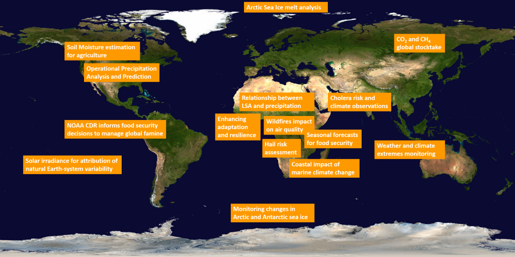
Summary of Use Cases and their geographical locations