Within Latin American, only about 35% of the potentially active volcanoes have some type of seismic, deformation or gas monitoring according to the United Nations Global Assessment of Risk 2015 report (GAR15). To demonstrate how satellite observations can be used to cost-effectively monitor all 315 volcanoes in the region that erupted in the last 10,000 years, CEOS began a 3-year volcano pilot project to complement the available ground observations.
During the first 18 months of the pilot project, an international group of experts in remote sensing have provided imagery from the partner space agencies to the volcano observatories in the Latin American countries who are governmentally responsible for volcano monitoring, and they have worked together to interpret the data, which have been used to identify unrest at such volcanoes as Chiles-Cerro Negro (Colombia-Ecuador border), (Sabancaya) (Perú), and Guallatiri (Chile). Although no large eruptions have yet occurred at these volcanoes, the satellite data provided unique information on ground deformation and thermal characteristics that would not otherwise be known because of a lack of ground sensors.
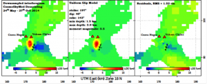
The Chiles-Cerro Negro unrest is perhaps the most intense. Chiles and Cerro Negro are stratovolcanoes on the Ecuador-Colombian border that, until recently, had no historical activity. Since 2013 unrest has persisted at the volcanoes, culminating in a swarm of several thousand volcano-tectonic earthquakes per day in October 2014. At the height of this unrest there was a M5.6 earthquake just south of Volcán Chiles. CEOS data, in particular CosmosSkyMed and TerraSAR-X interferograms, showed about 30 cm of ground movement associated with this earthquake, and allowed us to estimate the position and slip on the fault plane that ruptured (Figure). Larger earthquakes that occur during volcanic unrest can tell us about changes to the subsurface stress field and are important to understand for assessing volcanic hazard.

Observed (left), modeled (center), and residual (right) deformation at Chiles-Cerro Negro on the Ecuador-Columbia border based on a COSMO-SkyMed interferogram spanning May 24–October 27, 2014. Deformation in the image is modeled as mostly due to reverse faulting along the M5.6 slip plane. Courtesy of ASI.
Partner agencies: SERNAGEOMIN, Chile; Observatorio San Calixto, Bolivia; Instituto Geofísico del Perú, Instituto Geofísico de la Universidad Nacional de San Agustín, Peru; Instituto Geofísico, Escuela Politécnica Nacional, Ecuador; Servicio Geológico Colmbiano; University of Bristol, UK; Cornell University, USA; National Research Council of Italy, Istituto Per Il Rilevamento Elettromagnetico Dell’Ambiente, University of Miami, USA; Pennsylvania State University, USA