CEOS Support to SDG 15: Life On Land
This is the fifth in a series of six articles focusing on the UN Sustainable Development Goals (SDGs), and how Earth observation, in particular CEOS, can help in reaching these goals. The series of articles includes:
- CEOS Support to SDG 15: Life on Land (this article)
The series has been prepared in support of the 2022 CNES CEOS Chair’s Priority #1: Paths to Sustainability, alongside the 2022-23 ESA SIT Chair’s thematic priority on the Sustainable Development Goals and the 2030 Agenda. The work is drawn from the previous SDG ad hoc team, co-lead by CSIRO and ESA.
Terrestrial ecosystems provide critical support to humanity in many ways, through the provision of food,  raw construction materials and energy sources. They also capture carbon from the atmosphere, maintain soil quality, provide habitats for biodiversity and maintain water quality, as well as contribute to reducing the risks of natural disasters such as floods and landslides through the regulation of water flow and erosion control. Maintaining those ecosystems greatly support climate change mitigation and adaptation efforts.
However, life on land is under increasing stress. Human activity has altered almost 75 percent of the Earth’s terrestrial surface, squeezing wildlife and nature into an ever-smaller corner of the planet. Satellite Earth observations are unique in their ability to provide consistent and comparable information on global land cover. Optical imagery may be used to measure the type and extent of land cover and their change over time. This is complemented by radar imagers that can provide further information on vegetation height, structure, soil moisture and biomass and can measure day-and-night, in all weather conditions, and ‘through’ some forest canopies.
CEOS work for SDG 15 has focused on Target 15.3: By 2030, combat desertification, restore degraded land and soil, including land affected by desertification, drought and floods, and strive to achieve a land degradation-neutral world, and specifically, providing support for Indicator 15.3.1: Proportion of land that is degraded over total land area. The UN Convention to Combat Desertification (UNCCD) commissioned a series of Good Practice Guidance reports (GPG) to help countries select, process and analyse datasets to measure the extent of degraded land and report against the three sub-Indicators: Land Cover and Land Cover Change, Land Productivity, and Carbon Stocks Above and Below Ground (for which the surrogate of Soil Organic Carbon stocks is currently used). EO data analytics are closely integrated into the recommended methods for each of these sub-indicators. In 2021, the CEOS SDG team provided updated dataset recommendations consistent with the revised Version 2 of the GPG , referencing CEOS-ARD. CEOS is currently working closely with the GEO Land Degradation Neutrality (LDN) Initiative to identify options to address some of the emerging data and analytics needs for Indicator 15.3.1 that were identified during the recent SDG reporting processes. GEO LDN is supported by the UNCCD and funding from the BMZ (Germany) and is aligned to SDG Goal 15.3 which strives to achieve a land degradation neutral world. .
The Global Forest Observations Initiative (GFOI) works closely with CEOS to work on achieving Target 15.2: By 2020, promote the implementation of sustainable management of all types of forests, halt deforestation, restore degraded forests and substantially increase afforestation and reforestation globally, and providing support for Indicator 15.2.1: Progress towards sustainable forest management. GFOI aims to provide countries with wall-to-wall national coverage of satellite data, in addition to methods and guidance documentation that will facilitate reporting consistent with the Intergovernmental Panel of Climate Change (IPCC) Good Practice Guidance. This will allow countries and donors to have confidence in agreements, as well as ensuring consistency and comparability among reporting countries. CEOS Agencies have committed to providing global annual coverage of the world’s forests to ensure that countries have the minimum data necessary to participate in frameworks focused on sustaining forest cover.
The Global Land Analysis and Discovery (GLAD) laboratory in the Department of Geographical Sciences at the University of Maryland investigates methods, causes and impacts of global land surface change. Also focusing on Target 15.2, and Indicator 15.2.1, GLAD uses Earth observation imagery as the primary data source. The National Aeronautics and Space Administration (NASA) of the USA has helped develop this initiative, which uses Landsat time-series data archives to produce global forest cover maps, available for every 16 days from 1997 to the present.
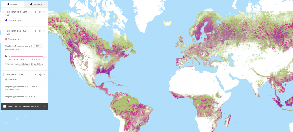
Global Forest Watch map, showing tree cover loss and gain from 2001-2021. Visit https://www.globalforestwatch.org/map/ to view the interactive map.