CEOS Support to SDG 11: Sustainable Cities and Communities
This is the third in a series of six articles focusing on the UN Sustainable Development Goals (SDGs), and how Earth observation, in particular CEOS, can help in reaching these goals. The series of articles includes:
- CEOS Support to SDG 11: Sustainable Cities and Communities (this article)
The series has been prepared in support of the 2022 CNES CEOS Chair’s Priority #1: Paths to Sustainability, alongside the 2022-23 ESA SIT Chair’s thematic priority on the Sustainable Development Goals and the 2030 Agenda. The work is drawn from the previous SDG ad hoc team, co-led by CSIRO and ESA.
 The world is becoming increasingly urbanised. Since 2007, more than half of the world’s population has been living in cities, and that share is projected to rise to 60% by 2030. Cities and metropolitan areas are powerhouses of economic growth – contributing about 60% of global GDP. However, they also account for about 70 per cent of global carbon emissions and over 60 per cent of resource use. Rapid urbanisation is resulting in a growing number of slum dwellers, inadequate and overburdened infrastructure and services (such as waste collection, water and sanitation systems, roads and transport), worsening air pollution and unplanned urban sprawl.
A number of global urban extent datasets derived from satellite observations have been developed such as the Global Human Settlement Layer (GHSL) and the World Settlement Footprint 2019 & Evolution. These global datasets of urban extent, thanks to the use of Big Data analytics platforms like the U-TEP, enable the production of evidence-based knowledge on the properties of human settlements such as area, shape, imperviousness, greenness, pattern and network of settlements and, in the future, even volumes of buildings. When combined with information on population, they constitute a major source of data to inform SDG Indicator 11.3.1 on land consumption rate.
Target 11.3
The CEOS SDG team has been focusing their work for SDG 11 on Target 11.3: By 2030, enhance inclusive and sustainable urbanisation and capacity for participatory, integrated and sustainable human settlement planning and management in all countries. In particular, they are focusing on indicator 11.3.1: Ratio of land consumption rate to population growth rate. The team recently published the EO Support Sheet for SDG Indicator 11.3.1, which details how satellite observations can contribute to the reporting for Target 11.3. The document discusses satellite data requirements and availability, EO data access, EO-based global datasets, available platforms and tools, and current international initiatives. It also describes a step-by-step guide for the integration of EO into the SDG Indicator framework, and provides recommendations for implementation.
Highlights of the team’s work include:
- Contribution to the launch of the Earth Observations Toolkit for Sustainable Cities and Human Settlements
- Strong collaboration with EO4SDG, UN Habitat, GEO Human Planet and GUOI, as well as over 30 organisations including national statistical offices, national mapping agencies, city authorities, academia, research institutions, non-governmental organisations, space agencies, and the private sector.
- Inclusion of a summary of EO data, tools, and use cases in the Toolkit.
- Development of the Degree of Urbanisation as a method to delineate cities, urban and rural areas (approved by the UN Statistical Commission for international comparison).
- Identification of the need for more rigorous validation or inter-comparison to evaluate the usefulness of global public datasets and tools for national and sub-national reporting
- Contribution to development of 11.3.1 one-pager as well as ‘ease of use’, ‘FAIRness’, and ‘authoritative data’ frameworks to be integrated into the Toolkit.
Target 11.6
Another target of SDG 11 is Target 11.6: By 2030, reduce the adverse per capita environmental impact of cities, including by paying special attention to air quality and municipal and other waste management. Air pollution represents a significant environmental risk to health, and is also linked to climate change and ecosystem damage through the release of carbon dioxide, black carbon (soot), sulphur dioxide, nitrogen oxides, and other greenhouse gases. Monitoring the release of this pollution and its impact on air quality in the urban environment are keys to better-informed policies and assessment of the sustainability of development decisions.
The World Health Organisation (WHO) is the custodian agency for SDG Indicator 11.6.2: annual mean levels of fine particulate matter in cities. Using a variety of observations, including ground and satellite measurements, the WHO maintains an air quality database to support reporting and has developed the Data Integration Model for Air Quality (DIMAQ) to estimate human exposure to fine particulate matter. While CEOS is not directly involved with this Target, a number of CEOS Agencies, including the Japanese Aerospace Exploration Agency (JAXA) and CSIRO, Australia’s national science agency, are working closely on this matter. The teams are estimating fine particulate matter concentrations over cities by numerical modelling, integrating satellite data and in-situ data.
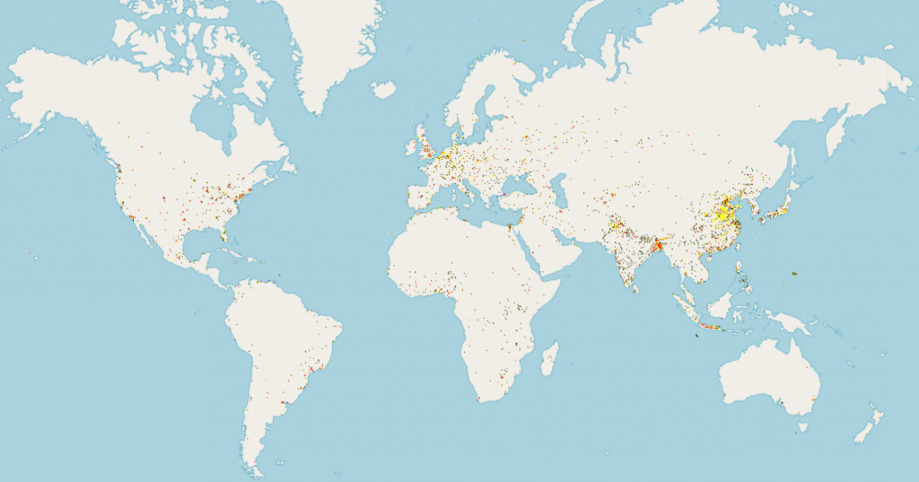
The Global Human Settlement Layer GHS-BUILT-S2, also showing the degree of urbanisation SMod-2015. Image: EC-JRC