CEOS Support to SDG 2: Zero Hunger
Co-authored by Alyssa Whitcraft (NASA Harvest & GEOGLAM)
This is the final in a series of six articles focusing on the UN Sustainable Development Goals (SDGs), and how Earth observation, in particular CEOS, can help in reaching these goals. The series of articles includes:
- CEOS Support to SDG 2: Zero Hunger (this article)
The series has been prepared in support of the 2022 CNES CEOS Chair’s Priority #1: Paths to Sustainability, alongside the 2022-23 ESA SIT Chair’s thematic priority on the Sustainable Development Goals and the 2030 Agenda. The work is drawn from the previous SDG ad hoc team, co-lead by CSIRO and ESA.
 The United Nations World Food Programme (WFP) has declared 2022 as “a year of unprecedented hunger”. Conflict, COVID-19, the climate crisis and rising costs have combined in 2022 to create jeopardy for up to 828 million hungry people across the world, with the number of those facing acute food insecurity soaring from 135 million in 2019, to 345 million today. The world’s increasing population, alongside climate change, will only increase pressures on food security, and hence a profound change of the global food and agriculture system is needed to alleviate the perils of hunger.
Satellite observations contribute to the production of timely information on agricultural production, including crop condition and yield. The information helps to inform food commodity markets, helping to limit extreme food price volatility and inform food security policy and response programs. Satellite measurements can be used to produce baseline maps of crop areas, crop types and growing season calendars. Satellite observations can also help detect soil moisture anomalies, contribute to crop condition assessment, and support modelling techniques that can forecast yield and generate production estimates that inform commodity markets.
While the CEOS SDG team is not currently working on SDG 2, there are many examples of CEOS Agencies using Earth observations for agriculture monitoring.
The Group on Earth Observations Global Agricultural Monitoring initiative (GEOGLAM) increases market transparency and improves food security by producing and disseminating relevant, timely, and actionable information on agricultural conditions, providing outlooks of production at national, regional, and global scales. It achieves this by strengthening the international community’s capacity to utilise coordinated, comprehensive, and sustained Earth observations. GEOGLAM was established in 2011 by the Group of 20 Agriculture Ministers as a part of its Food Price Volatility and Agriculture Action Plan to focus on large-scale agricultural assessment. Accordingly, GEOGLAM produces the Crop Monitor, which provides open, timely, and science-driven information on crop conditions in support of market transparency and early warning of production shortfalls. The Crop Monitor uses several key Earth observation datasets in their agricultural monitoring, including Normalised Difference Vegetation Index (NDVI), precipitation, temperature, soil moisture, and evapotranspiration.
![]()
GEOGLAM is supported by a number of national and regional sources. For example, the Copernicus4GEOGLAM programme within the Copernicus Global Land Service aims to strengthen national and sub-national level agricultural monitoring systems in GEOGLAM partner countries. The programme makes ground validated in-season and end of season crop type maps, crop masks and crop areas statistics available to users, based on data from the Copernicus Sentinel-1 and 2 satellites.
NASA Harvest is NASA’s food security and agriculture program, with the mission to enable and advance adoption of satellite Earth observations by public and private organisations to benefit food security, agriculture, and human and environmental resiliency in the US and worldwide. The program brings together experts on environmental, economic and social aspects of agriculture in space agencies, research organisations, humanitarian organisations, ministries of agriculture, and more. NASA Harvest leads the GEOGLAM Crop Monitor Activity, and recently co-led the effort to define and characterise use-focused Essential Agriculture Variables for GEOGLAM.
ESA’s WorldCereal programme is an EO based system for global cropland monitoring, creating a global research & development challenge aiming to engage the global agricultural community to achieve optimal results. The open-source WorldCereal system will offer access to in situ and satellite data, including Sentinel-1, -2, and -3 and Landsat 8, alongside tools to share reference data sets. The programme will also provide to users newly developed and tested state-of-the-art classification algorithms, the necessary cloud infrastructure, and visualisation tools to derive useful information from the produced maps. In June 2022, the WorldCereal team and other GEOGLAM partners published global crop calendars for wheat and maize, with an accompanying paper.
Utilising their Sentinel missions, ESA also hosts a number of open tools for agriculture at the sub-national scale. The Sen2-Agri system serves for the exploitation of Sentinel-2 for local to national operational agriculture monitoring. The system provides users with high resolution, preprocessed EO products from Sentinel-2 and Landsat-8, with access via a graphical user interface. The ESA Sen4Stat platform develops and demonstrates agricultural EO products and workflows based on the Sentinel missions which support agricultural statistics and can be integrated in the National Statistical Offices (NSO) environment. The Common Agricultural Policy (CAP) of the European Union aims at improving European agricultural productivity in a sustainable manner while ensuring a decent standard of living for farmers within the EU. This policy is supported by ESA through the Sen4CAP project, paying particular attention to provide evidence for how Sentinel derived information can support the modernization and simplification of the CAP in the post 2020 timeframe.
The Chinese Academy of Sciences and Institute of Aerospace Information Innovation host CropWatch, an agricultural monitoring system based on remote sensing and ground observation data that can independently assess crop growth, yield and other related information at the national and global scales. The Global Agricultural Situation Remote Sensing Quick Report publishes bilingual reports in both Chinese and English on a quarterly basis.
While GEOGLAM’s focus has been principally on a larger scale, national to global policy–oriented monitoring, satellite Earth observations, together with data from unmanned aerial vehicles (UAVs) and data collected in situ, can support the implementation of sustainable agriculture practices. Precision farming has its origins in the 1980s and aims to use spatially precise information to guide application of irrigation, nutrients, and crop protections at variable rates and only where needed. These practices have been adopted by many agricultural actors in large parts of the world, and now the next generation – precision sustainable agriculture – builds on and re-envisions this history to ensure that the methods which increase yields while decreasing input costs also focus on rebuilding soil health, better managing natural resources, and reducing negative environmental externalities. While the associated technologies are still in development, it is expected that satellite-based EO will provide the critical scaling function necessary to implement these benefits at scale at low cost and low latency.
GEOGLAM partners around the world are participating in the operational research and development of these technologies, leveraging both its JECAM (Joint Experiment for Crop Assessment and Monitoring) Research Sites as well as partner projects to ensure that the methods developed and implemented in policies and in markets are backed by robust science and calibrated satellite data. CEOS is supporting these important shift by coordinating satellite image acquisition over JECAM sites, by responding to the requirements laid out by the Essential Agriculture Variables (EAVs) for GEOGLAM, and through collaboration on calibration and validation requirements for cropland and crop type mapping by the CEOS WGCV Land Product Validation Group.
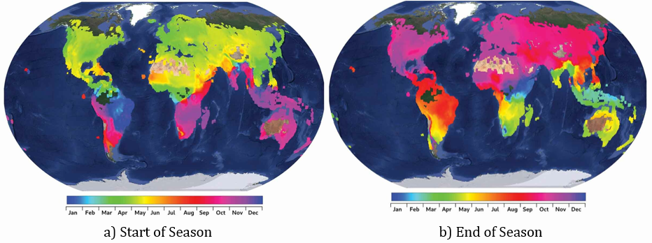
Maize crop calendar dates over a base map from the Google Earth dataset as produced by WorldCereal.