OCR-VC: What Have They Been Up To?
This article is the third in a series of seven articles describing the role and work of the CEOS Virtual Constellations. The series of articles is as follows:
- Atmospheric Composition (AC-VC)
- Land Surface Imaging (LSI-VC)
- Ocean Colour Radiometry (OCR-VC) (this article)
- Ocean Surface Topography (OST-VC) (coming soon)
- Ocean Surface Vector Wind (OSVW-VC) (coming soon)
- Precipitation (P-VC) (coming soon)
- Sea Surface Temperature (SST-VC) (coming soon)
The CEOS Virtual Constellations (or ‘VCs’) are defined as “a set of space and ground segment capabilities operating together in a coordinated manner, in effect a virtual system that overlaps in coverage in order to meet a combined and common set of Earth observation requirements.” The interim goal of each VC is to demonstrate the value of a collaborative partnership in addressing a key observational gap, while the end goal is to sustain the routine collection of critical observations. For more on what the VCs are in general, see the process paper.
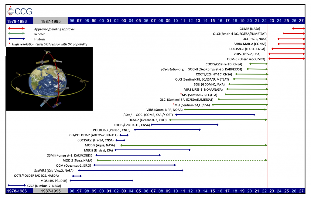
The Ocean Colour Radiometry Virtual Constellation (OCR-VC) was established in 2009, in coordination with the International Ocean Colour Coordinating Group (IOCCG). OCR-VC’s goal is to produce sustained data records of well-calibrated and validated satellite ocean colour datasets from measurements obtained from multiple satellites.
Key scientific and societal goals supported by the OCR-VC include:
- understanding and predicting synoptic states and information for the global ocean, coastal and inland waters related to biological, ecological and biogeochemical processes
- facilitating aquatic applications including monitoring and managing water quality, living marine resources and other crucial ecosystem goods and services
- understanding and predicting the impacts and feedbacks of climate variability and change on aquatic biology, ecology, and chemistry, and reducing the uncertainty on the estimates of carbon sequestration by the biological carbon pump
The scope of OCR-VC activities spans a large number of satellite-derived geophysical properties providing input on water optical conditions and related biogeochemical constituents. These include spectral remote sensing reflectances and radiances, concentrations of phytoplankton through their chlorophyll a signature, concentrations of total suspended matter, water optical turbidity, inherent optical properties such as particle backscattering and absorption by coloured dissolved organic matter, photosynthetically active radiation, phytoplankton functional types, primary productivity, and aquatic carbon retrievals.
In 2012, OCR-VC published the International Network for Sensor Inter-comparison and Uncertainty assessment for Ocean Colour Radiometry, or INSITU-OCR, white paper. The INSITU-OCR initiative aims to ensure accuracy and consistency in developing remote sensing products from multiple missions, with particular emphasis on requirements for Ocean Colour Essential Climate Variables (ECVs) as proposed by the Global Climate Observing System%nbsp;(GCOS). Key recommendations of the white paper address:
- space sensor radiometric calibration, characterization and temporal stability
- development and assessment of satellite products
- in situ data generation and handling
- information management and support
To support the INSITU-OCR white paper recommendations, OCR-VC established the OCR Implementation Team (OCR-IT) to prepare a rolling implementation plan encompassing a number of direct CEOS deliverables. The implementation includes agency level activities such as the ESA FRM4SOC and EUMETSAT FRM4SOC-2 projects as well as System Vicarious Calibration infrastructure developments from, for example, NASA and EC Copernicus. Overarching synergistic activities from various agencies include the development of IOCCG Ocean Optics and Biogeochemistry Protocols, IOCCG Sensor Calibration Task Force, IOCCG working groups and reports, and capacity building which involves summer schools, online resources and support for the CEOS COVERAGE initiative.

The UN Decade of Ocean Science places a focus transformative ocean science solutions for sustainable development, connecting people and our ocean.
OCR-VC is contributing to several themes of the current UN Decade of Ocean Science, covering a clean, safe, healthy and resilient, predictable, and transparent ocean. OCR-VC is also working to deliver datasets in support of one of the central research focuses of the Decade to understand the processes of ocean carbon export. Furthermore, OCR-VC provides support to the Group on Earth Observations (GEO) Blue Planet initiative, involving tasks on sustained ocean observations (including OCR ECVs), sustained ecosystems and food security, ocean forecasting, services for coastal zones, ocean carbon, and developing capacity and social awareness.
CEOS has recently begun considering the creation of an Aquatic Carbon Roadmap, an effort led by OCR-VC. In February 2022, ESA, alongside OCR-VC, hosted an Ocean Carbon from Space workshop. A special issue in Frontiers in Marine Science was launched to capture individual contribution to the workshop and related work, and a community whitepaper was also produced to gather the workshop outcomes and recommendations. This whitepaper, which captures the contributions from the community, has been submitted to the Aquatic Carbon From Space Special Issue in Earth Science Reviews (expected to be finalised early 2023). These two activities have created a strong momentum around aquatic carbon from space, a key contribution to the Global Carbon Budget.
The CEOS Aquatic Carbon Roadmap would complement the existing Greenhouse Gas (GHG) Roadmap, and the upcoming Agriculture, Forestry and Other Land Use (AFOLU) Roadmap. The aim is to summarise what is known right now about the Aquatic Carbon and its role in the global carbon cycle, identify which variables can be provided in the context of global integrated carbon monitoring, and provide a roadmap towards filling the main knowledge gaps, focusing on a few major gaps to which all agencies can contribute.
