OST-VC: What Have They Been Up To?
This article is the third in a series of seven articles describing the role and work of the CEOS Virtual Constellations. The series of articles is as follows:
- Atmospheric Composition (AC-VC)
- Land Surface Imaging (LSI-VC)
- Ocean Colour Radiometry (OCR-VC)
- Ocean Surface Topography (OST-VC) (this article)
- Ocean Surface Vector Wind (OSVW-VC) (coming soon)
- Precipitation (P-VC) (coming soon)
- Sea Surface Temperature (SST-VC) (coming soon)
The CEOS Virtual Constellations (or ‘VCs’) are defined as “a set of space and ground segment capabilities operating together in a coordinated manner, in effect a virtual system that overlaps in coverage in order to meet a combined and common set of Earth observation requirements.” The interim goal of each VC is to demonstrate the value of a collaborative partnership in addressing a key observational gap, while the end goal is to sustain the routine collection of critical observations. For more on what the VCs are in general, see the process paper.
The Ocean Surface Topography Virtual Constellation (OST-VC) is made up of members of the various institutes that have launched satellite altimeters since the start of the field with Seasat in 1978. It aims to coordinate efforts in providing data users – meteorological offices, oceanographers, geodesists, glaciologists, hydrologists, climate scientists, etc. – with an optimal data quality, coverage and spatial and temporal resolution.
The strength for OST-VC is the strong link with the OSTST (Ocean Surface Topography international science team). This science team is selected every 4 years by representatives from NASA, CNES and EUMETSAT. OSTST guarantees the quality of data from the altimetry reference mission which is used for the intercalibration of the international altimetry fleet and the overall quality of the altimetry products from all missions. OST-VC often takes advantage of the OSTST annual meeting to hold side meetings with their members.
OST-VC aims to implement a sustained, systematic capability to observe the surface topography of global oceans from the basin scale to the mesoscale (~ 100 km). It focuses on global sea level rise, the role of the oceans in climate, and operational oceanography. Information from the OST Constellation supports the GEO Social Benefits Areas of disasters, climate, water, and weather.
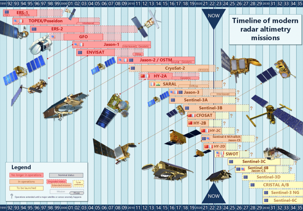
The surface topography measurements from satellite altimeters are used in conjunction with in situ data and models, to help increase the understanding of the dynamics of the oceans, assessing their role in climate, and developing an operational forecast capability. The CEOS OST-VC coordinates the missions known as reference altimetry missions, which have been making standardised measurements of the fluctuations of sea level near and far. They provide a unified ocean topography record and the equivalent coverage of a half-million tide gauges. The modern radar altimetry missions include TOPEX/Poseidon (1994-2001), Jason-1 (2001-2009), Jason-2/OSTM (2009-2016), Jason-3 (2016- ), and the current Sentinel-6A Michael Freilich (2020- ). The future is also planned, with Sentinel-6B scheduled to take over in 2025, and Sentinel-6C in 2030. These reference satellites are supported by a number of other contributing altimeters, from many different CEOS Agencies.
The latest updates about the constellation are the following:
- On 7 April, 2022, Sentinel-6 Michael Freilich was declared the new altimetry reference satellite, allowing Jason-3 to move into its interleaved orbit. Read more about this in the article posted to announce the news.
- The TOPEX/Poseidon mission recently celebrated its 30th Birthday in orbit in August 2022. While no longer operational since 2006, TOPEX/Poseidon delivered an astonishing 13+ years of data from orbit, well outlasting its 3-5 year design life.
- The new CNES / NASA joint altimetry mission is set to launch NET (Not Early Than) 5 December, 2022: the Surface Water and Ocean Topography (SWOT) mission, developed with support from CSA and UKSA. With the innovative wide-swath altimetry, SWOT is the first mission dedicated to the globe’s inland waters. SWOT will also survey coastal waters and observe ocean waters with a resolution 10 better than currently.
- CFOSAT recently passed 4 years in orbit, and a mission extension will be decided very soon.
- The joint ISRO-CNES SARAL–AltiKa mission is functioning in mispointing mode, and has been extended until December 2023.
- The Sentinel-3 constellation is fully operational, with 2 satellites currently in orbit.
In 2009, the Next 15 years of altimetry – OST Constellation User Requirements document was published, and OST-VC is currently planning an update, to integrate new user needs from recent books and white papers from the community. Delivery of this white paper is expected towards the end of 2023.
