CEOS Support to SDG 14: Life Below Water
This is the fourth in a series of six articles focusing on the UN Sustainable Development Goals (SDGs), and how Earth observation, in particular CEOS, can help in reaching these goals. The series of articles includes:
- CEOS Support to SDG 14: Life Below Water (this article)
The series has been prepared in support of the 2022 CNES CEOS Chair’s Priority #1: Paths to Sustainability, alongside the 2022-23 ESA SIT Chair’s thematic priority on the Sustainable Development Goals and the 2030 Agenda. The work is drawn from the previous SDG ad hoc team, co-lead by CSIRO and ESA.
The ocean drives many global systems that make the Earth habitable for humankind. Our rainwater,  drinking water, weather, climate, coastlines, much of our food, and even the oxygen in the air we breathe, are all ultimately provided and regulated by the sea. It hence follows that careful management of this essential global resource is a key feature of a sustainable future. There is currently a continuous deterioration of coastal waters owing to pollution, and ocean warming and acidification is having an adversarial effect on the functioning of ecosystems and biodiversity.
Satellite imagery can contribute to monitoring and sustaining of marine resources and is featured in the plans of SDG 14 custodian agencies and supporting activities. This includes the monitoring of coastal eutrophication and floating plastic debris density, as well as the regulation and monitoring of illegal fishing activities. Satellites can help to address the challenges of the vast scale, and the difficulty in accessing many areas of the world’s oceans.
The CEOS Coastal Observations Applications Services and Tools (COAST) Ad Hoc Team leads the CEOS effort regarding SDG 14, with support from the CEOS SDG Team, and in partnership with GEO Blue Planet and GEO AquaWatch. Their work focuses on Target 14.1: By 2025, prevent and significantly reduce marine pollution of all kinds, in particular from land-based activities, including marine debris and nutrient pollution, and specifically Indicator 14.1.1a): Index of coastal eutrophication. By measuring chlorophyll-a concentration, the team can estimate the algal biomass in surface waters, which, in turn, provides an indicator of eutrophication. This indicator data was included in the 2021 SDG report.
The team has also been working with regional UN Environment leads to bring together the national statistical offices and the national scientists and CEOS agencies to improve the utility of indicators and develop useful tools for member countries.
Further development is needed of merged/gap-free coastal ocean colour products at highest possible spatial resolutions, and as such CEOS-COAST, GEO Blue Planet & GEO AquaWatch are working on developing cross-CEOS connections with the Ocean Colour Radiometry Virtual Constellation (OCR-VC) to discuss emerging approaches/solutions for global, regional and national needs. The teams are also hoping to pursue Artificial Intelligence and/or Machine Learning approaches that provide an integrated, trans-boundary approach for an improved coastal eutrophication indicator that uses both land and sea data.
Global Eutrophication Watch data portal
A number of CEOS Agencies have also been working on regional tools to monitor ocean eutrophication inline with indicator 14.1.1a.
Australian CEOS Agencies, CSIRO and the Bureau of Meteorology (BOM), have been working with the Great Barrier Reef Marine Park Authority to monitor the condition and trend of the Great Barrier Reef inshore water quality. The project uses daily ocean-colour satellite observations from MODIS-Aqua, complemented by in-situ observations for validation. CSIRO provides the eReefs data visualisation portal, which provides access to water quality data over the Great Barrier Reef.
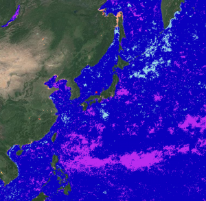
Supported by JAXA, the Northwest Pacific Action Plan (NOWPAP) Special Monitoring and Coastal Environmental Assessment Regional Activity Centre (CEARAC) has used remote sensing data to prepare long-term, consistent chlorophyll-a datasets to be used for a standardised eutrophication assessment procedure. The Global Eutrophication Watch is designed to allow users to perform a preliminary screening of coastal eutrophication using satellite-derived chlorophyll data. A default MODIS/Aqua-derived chlorophyll product is bundled with the application, however users can also provide a link to their own asset of monthly chlorophyll data.
A regional indicator for Europe has been developed, and is currently in press in the Journal of Operational Oceanography and will be released soon. ISRO is also working on a regional algorithm for chlorophyll in support of SDG 14 in collaboration with CEOS COAST.