Multi-Mission Algorithm and Analysis Platform (MAAP) Biomass Dashboard
Biomass, the living part of vegetation systems, plays a crucial role in climate. Around half of biomass is carbon, so when vegetation is destroyed, as in deforestation, carbon dioxide is released to the atmosphere. This is a huge source of atmospheric carbon – about 6 billion tons of carbon dioxide per year. At the same time, vegetation growth pulls carbon dioxide out of the atmosphere and stores it as biomass. Hence, biomass and its change over time, especially forest biomass, is a key part of both the climate problem and its solution. Mapping aboveground biomass is therefore a priority of several ongoing, new and upcoming CEOS Agency satellite missions, including GEDI (Global Ecosystem Dynamics Investigation), ICESat-2 (Ice, Cloud, and Land Elevation Satellite 2), Sentinel-1, ALOS (Advanced Land Observing Satellite) -2 & -4, Biomass and NISAR (NASA ISRO (Indian Space Research Organisation) Synthetic Aperture Radar).
Several current projects are producing continental to global biomass maps. These include the European Space Agency’s (ESA) Climate Change Initiative (CCI) Biomass global maps at a scale of 100 m for 2010, 2017, 2018, 2020; NASA JPL’s (National Aeronautics and Space Administration Jet Propulsion Laboratory) global 100 m map for 2020, and a time series of 10 km biomass maps from 2000-2020; NASA GEDI’s 1 km map for 2020 covering latitudes between about 52° N and 52° S; the NASA ICESat-2 30 m boreal map for 2020; and the UK National Centre for Earth Observation 100 m time series of maps for Africa from 2007 to 2017. Series of biomass change maps are also becoming available.
This new generation of biomass products will provide improved global and regional estimation of carbon fluxes from forest changes, but their widespread take-up requires that their differences are addressed and their accuracy is known. The world’s Earth Observation biomass community, coordinated through CEOS, is therefore undertaking a programme aimed at resolving discrepancies between products and producing harmonized estimates of biomass and uncertainty at a policy-relevant, jurisdictional-level scale. This effort builds on the CEOS biomass calibration and validation protocol, as well as reference data and tools available and used by CEOS partners. Key global biomass production and validation teams, including national experts, are engaged in this effort, with a shared goal of producing harmonized biomass products for use in the UNFCCC (United Nations Framework Convention on Climate Change) Global Stocktake (GST) process, with anticipated release in the first half of 2022. Besides the global harmonization effort, the community is working with varying country experts and agencies to demonstrate the uptake of space-based biomass to improve national biomass and forest carbon stock estimation in different country circumstances.
Over the last two years, NASA and ESA have collaborated under the JPPG (Joint Program and Planning Group) Joint Working Group on Ground Segment and Operations to develop the Multi-Mission Algorithm and Analysis Platform (MAAP). MAAP is a revolutionary open-source science tool for analyzing Earth science data in the cloud and is a model for open-source science collaboration and analysis.
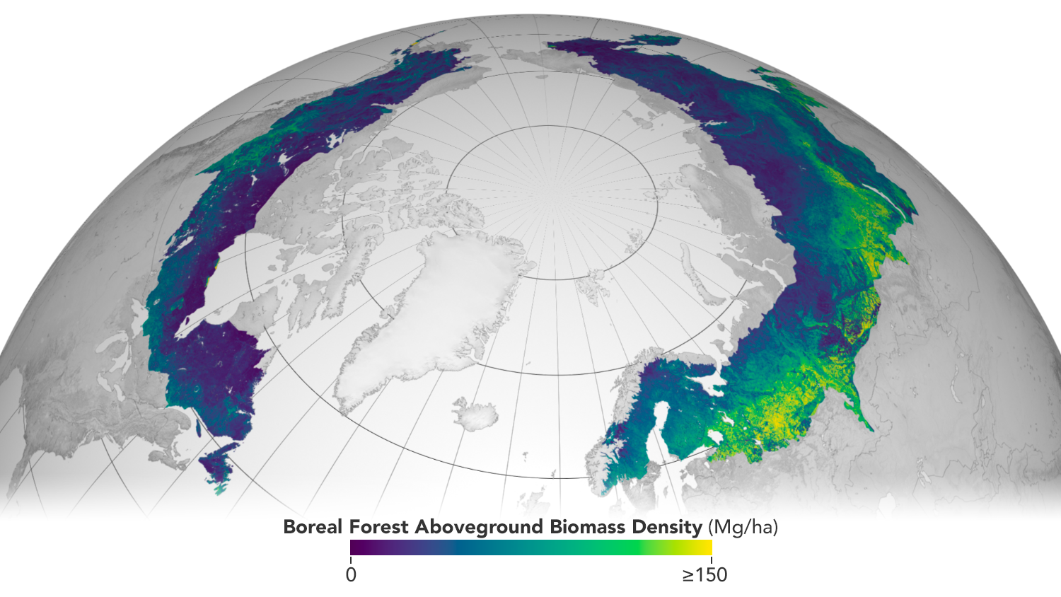
Circumboreal forest biomass density mapped at high spatial resolution (30 m) with NASA’s ICESat-2, the joint NASA/USGS Landsat-8, and ESA Copernicus Digital Elevation Model (DEM) data. This provisional product is representative of 2020 conditions and is an open-source science product created on the NASA-ESA MAAP platform.
The MAAP infrastructure was leveraged to develop a site to host the CEOS biomass harmonization activity, with specific contributions from NASA, ESA and JAXA (Japan Aerospace Exploration Agency). CEOS has contributed to this effort through providing coordination through the teams from the CEOS Land Surface Imaging Virtual Constellation (LSI-VC) Forests & Biomass Subgroup (led by Frank Martin Serief (ESA) and Osamu Ochiai (JAXA)), and the CEOS Working Group on Calibration & Validation (WGCV) Land Product Validation (LPV) Biomass Subgroup (led by Laura Duncason and John Armston (University of Maryland), and Mat Disney (University College London)). The resulting tool is known as the MAAP Biomass Dashboard, and can be accessed online to explore the capabilities.
MAAP enables international scientists and researchers to collaboratively develop algorithms and code, as well as analyse and visualise large datasets acquired from sources including satellite instruments and the International Space Station, as well as airborne and ground campaigns. The large data and high-performance computing required for MAAP, along with a shared code repository and catalog, are stored and managed in the cloud.
The work on the MAAP Biomass Dashboard complements the work on the new CEOS GST portal, which was developed to support the first GST in 2023. GST Portal resources provide a single point of access to all the datasets and guidance resulting from CEOS GST activities, with descriptions provided for each dataset, along with links to the data itself, available user manuals or guidance documentation, and point of contact information for each case. To read more about this tool, check out this recent post.