LSI-VC-4 / SDCG-12 / GEOGLAM Trial Joint Meetings
A Joint Meeting between the CEOS Land Surface Imaging Virtual Constellation (LSI-VC), the CEOS Space Data Coordination Group for the Global Forest Observations Initiative (SDCG) and the Group on Earth Observations Global Agricultural Monitoring Initiative (GEOGLAM).
Location: Frascati, Italy
Hosted By: The European Space Research Institute (ESRIN)
Minutes V1.0 FINAL (4 December 2017) PDF | DOC
Please refer to this page for common logistics information (hotels, transfers, week-at-a-glance), but more detailed information about each individual meeting can be found at the links below:
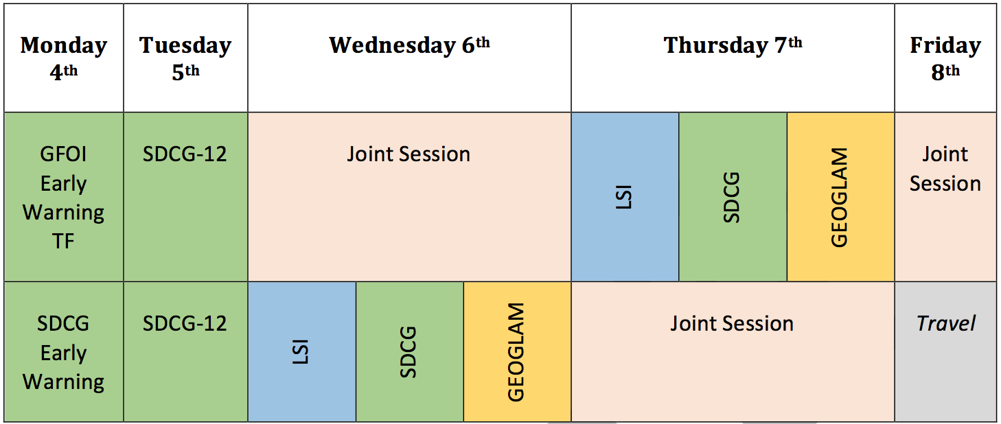
Week at a Glance
Logistics
Joint Meeting Agenda (v.07): [ Word | PDF ]
Wednesday September 6th, 2017
|
08:30 – 09:00 |
Welcome Coffee | ||
| Session 1: Welcome | |||
|
J1 |
09:00 – 09:10 |
Welcome Remarks Tour de table introductions |
Co-Leads: LSI-VC, SDCG, GEOGLAM |
|
J2 |
09:10 – 09:20 |
Overview and Recap [presentation]
|
S Ward (SIT Chair Team) |
|
J3 |
09:20 – 10:00 |
Core Mission Status
|
|
|
Session 2: Analysis Ready Data (A Lewis, LSI-VC Chair) |
|||
|
J4 |
10:00 – 10:10 |
CARD4L Overview and Status [presentation]
|
Adam Lewis (LSI-VC) |
|
J5 |
10:10 – 10:30 |
CARD4L-Compliant Product Generation
|
USGS TBA, ESA TBA |
|
J6 |
10:30 – 10:40 |
ARD Needs and Plans for Thematic Pilots [presentation]
|
B Killough |
|
J7 |
10:40-10:50 |
GOES-16 Surface Reflectance Products Discussion on CARD4L potential and value for land applications (forests, ag, others) |
All |
|
J8 |
10:50 – 11:10 |
Discussion Broader CEOS ARD Strategy |
All |
|
11:10 – 11:30 |
Break and Photo | ||
|
Session 3: Moderate Resolution Sensor Interoperability (E Fosnight, Chair) |
|||
|
J9 |
11:30 – 11:45 |
Overview [presentation]
|
E Fosnight |
|
J10 |
11:45 – 12:00 |
Harmonized Landsat Sentinel-2 HLS case study |
J Masek |
|
J11 |
12:00 – 12:15 |
EC/ESA MRI-related activities |
All |
|
J12 |
12:15 – 13:00 |
Discussion time
|
All |
|
13:00 – 14:00 |
Lunch | ||
|
14:00 – 18:00 |
|||
Thursday, September 7th, 2017
|
09:00 – 13:00 |
Parallel meetings LSI-VC-4, SDCG-12, and GEOGLAM. | ||
| 13:00 – 14:00 | Lunch | ||
| Session 4: Pilots: Global Data Flows and FDA (B Killough, SEO, Chair) | |||
|
J13 |
14:00 – 14:10 |
Session Overview |
B Killough |
|
J14 |
14:10 – 14:20 |
Review of Global Data Flows Study [presentation] [Better Than Free] |
G Dyke |
|
J15 |
14:20 – 14:50 |
FDA Update and Implications [presentation]
|
S Ward |
|
J16 |
14:50 – 15:00 |
Report on Copernicus Data and Information Access Services (DIAS) [presentation] |
B Rosich (TBC) |
|
J17 |
15:00 – 15:20 |
Data Cube Pilots
|
B Killough |
|
J18 |
15:20 – 15:45 |
Discussion |
All |
|
15:45 – 16:00 |
Break | ||
|
Session 5: Land Surface Imaging Requirements (J Lacey, LSI-VC, Chair) |
|||
|
J19 |
16:00 – 16:30 |
Land Imaging Requirements Assessment [presentation]
|
A Whitcraft |
|
J20 |
16:30 – 17:00 |
Systems Engineering Tools for Integrated Land Surface Imaging
|
B Killough |
|
J21 |
17:00 – 18:00 |
Discussion: Land surface imaging requirements and CEOS integrated observing strategy Including gap analysis objectives |
All |
Friday, September 8th, 2017
|
08:30 – 09:00 |
Welcome Coffee | ||
|
Session 5: Review of Meeting Outcomes |
|||
|
J22 |
09:00 – 09:15 |
GEOGLAM Meeting Main Outcomes [presentation] |
GEOGLAM Co-Leads |
|
J23 |
09:15 – 09:30 |
SDCG-12 Main Outcomes [presentation] |
SDCG Co-Leads |
|
J24 |
09:30 – 09:45 |
LSI-VC-4 Main Outcomes [presentation] |
LSI-VC Co-Leads |
|
Session 6: Review of Joint Way Forward and Closing |
|||
|
J25 |
09:45 – 10:00 |
Options for Joint Way Forward [presentation] |
SIT Chair Team |
|
J26 |
10:00 – 10:30 |
Discussion of Options for Joint Way Forward |
All |
|
10:15 – 10:30 |
Break | ||
|
J27 |
10:30 – 11:00 |
Discussion of Options for Joint Way Forward (continued)
|
All |
|
|
11:00 – 11:15 |
Presentation of Joint Meeting Outcomes to SIT Technical Workshop Coordination of a joint briefing from the LSI-VC, SDCG, and GEOGLAM ad hoc WG Co-Leads to SIT TWS |
All |
|
J28 |
11:15 – 12:00 |
Additional discussion on coordination topics |
All |
|
J29 |
12:00 – 12:15 |
Review of Actions |
Secretariat |
|
J30 |
12:15 – 12:30 |
Closing Remarks |
Co-Leads: LSI-VC, SDCG, GEOGLAM |
|
12:30 |
Lunch |