High Level Schedule of COAST Activities, Years 2024-2030
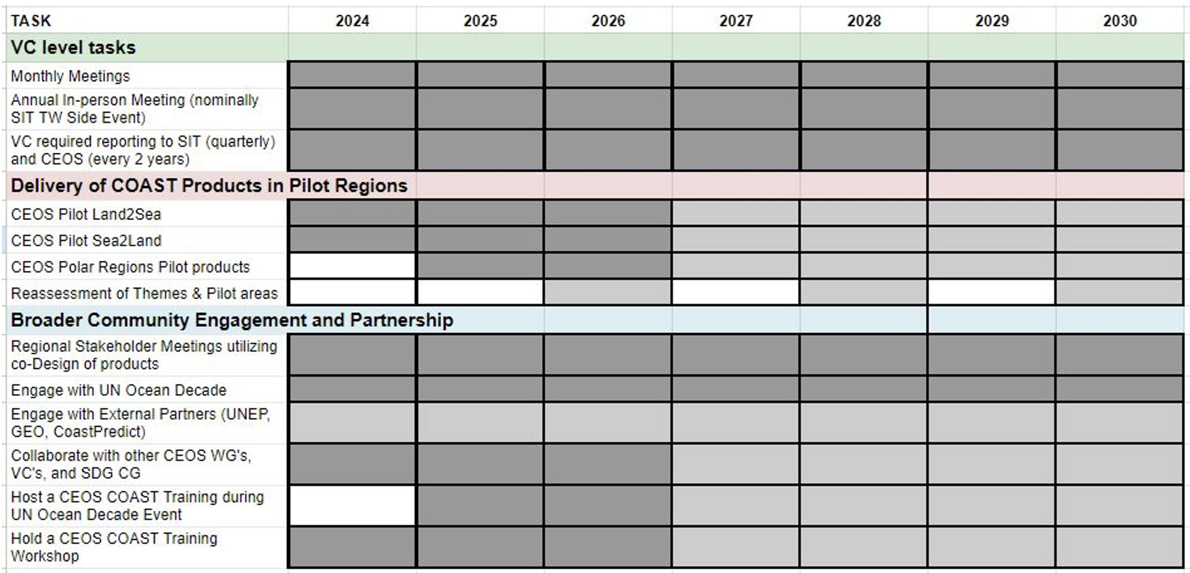
Focus Areas

History of COAST
One of the outcomes identified during the Ocean and Water Session of the Virtual Constellation/Working Group (VC/WG) Day of the 2018 CEOS Strategic Implementation Team (SIT) Technical Workshop was the suggestion for CEOS to consider potential pilot projects in the coastal zone targeting high priority user needs (e.g., flooding, water quality). This traces back to previous extensive CEOS engagement in the Integrated Global Observing System (IGOS) Coastal Theme Report (2006) and Coastal Global Ocean Observing System (GOOS) activities and more recently in the GEO Blue Planet Initiative, and noting that a majority of the world’s population lives within close proximity of a coastal zone.
At SIT-34, ongoing CEOS Agency interest in analysis ready satellite data provision for the coastal domain was discussed, as was the potential for a future workshop on coastal observation coordination. An action was given to the CEOS Blue Planet Expert (Paul DiGiacomo) to bring forward ideas for a coastal observing and applications study team. Dr. DiGiacomo presented on the coastal strategy topic during the VC/WG/ad hoc (AHT) Day and again at the 2019 SIT Technical Workshop. He recommended that the SIT establish a Coastal Study Team that would define the objective, scope, priorities, and value chain approach for a CEOS coastal engagement strategy, including identification of potential pilot project(s) and the engagement strategy with internal and external stakeholders.
In response to this action, a CEOS Coastal Observations and Applications Study Team (CEOS-COAST) was proposed and approved at the 33rdCEOS Plenary in October 2019. Agencies were requested to express their interest in participating on CEOS-COAST and to identify participants with appropriate expertise and interest. In January 2020, the CEOS-COAST kickoff meeting was held virtually, with extensive CEOS Agency, Working Group and Virtual Constellation participants, as well as experts from GEO Secretariat and the GEO Blue Planet and AquaWatch Initiatives. Regular monthly meetings, coupled with more frequent special topic meetings, were held throughout 2020 to coordinate and prepare COAST Phase 1 deliverables for the 2020 SIT Technical Workshop. These included three scoping whitepapers for COAST Phase 2 pilot activities in 2021, a compilation of relevant international projects, and an annotated bibliography (see https://ceos.org/ourwork/ad-hoc-teams/ceos-coast/). In response to these COAST Phase 1 activities and deliverables, the request to transition COAST from a Study Team into CEOS-COAST AHT was approved in October 2020, with Indian Space Research Organisation (ISRO) formally confirming that they would serve as Co-lead, complementing NOAA in this capacity.
Between 2021 and 2023 the COAST Team compiled and refined products for the two pilots, 5 themes and 5 geographical demonstration areas. Two successful user outreach events occurred in conjunction with GEO, one daylong stakeholder engagement event was held with partners in the Bay of Bengal region in 2022, and nearly a dozen stakeholder events have been held with partners in the Chesapeake Bay region. In accordance with CEOS program governance, efforts began in 2022 to sustain COAST activities within another CEOS entity. After much consideration, a cross-cutting Virtual Constellation was pursued and COAST-VC Terms of Reference and Phase 2 Implementation Plan documents were approved in April 2024 at SIT-39.
Rationale for a COAST-VC
Coastal zones are extraordinarily important from a societal and economic perspective. They are home to much of the global population, amongst the most productive ecosystems on Earth, and crucial to the emerging Blue Economy as essential sites of commerce, transportation, food security, and recreation. Within both developed and developing nations, coastal zones continue to grow and diversify. In this regard, there is a compelling need to better observe, understand, manage, and predict changes in these regions in support of sustainable development. Our ability and more so capacity to address changes in these regions is still relatively limited, particularly in the developing world. Coastal zones are characterized by complex processes, with rapidly changing and evolving conditions that can be challenging to effectively observe in both time and space, particularly given their inherent transboundary and transdisciplinary nature. Within coastal zones there is dynamic coupling of terrestrial, aquatic and atmospheric domains; complex, episodic and often ephemeral physical and biological/biogeochemical processes; and finally, the overarching challenge of integrating environmental sciences with social sciences.
There are also significant risks and threats to human health and safety, as well as the abundant ecosystem resources from these regions. Coastal hazards such as flooding and inundation, as well as water quality and associated impacts (e.g., eutrophication, hypoxia, harmful algal blooms, sediment loadings and coral reef et al. habitat degradation) to ecosystem health and productivity, represent particularly great challenges for society to address. The Committee on Earth Observation Satellites (CEOS) formed COAST (Coastal Observations, Applications, Services and Tools) to address these and other challenges and risks in the coastal zone, toward providing new and improved scientific/technical capabilities and building capacity for a more robust end-to-end value chain (observations to data to products to information to actionable knowledge) in support of coastal stakeholders and global sustainable development.
Focusing on this user-driven value chain, the COAST-VC facilitates targeted work and engagement on priority coastal observations and applications within CEOS, addressing the identification, extension/expansion, integration and transformation of multi-sensor observations into fit-for-purpose information supporting existing and emerging stakeholder requirements. This dedicated coastal-focused activity helps bridge land and aquatic observations within CEOS, and given its cross-cutting nature, will integrate across multiple CEOS entities and domains, both thematic and technical.
There is a compelling need to better observe, understand, manage, and predict changes in coastal regions for societal benefit and sustainable development. COAST VC seeks to address a gap in meeting coastal user needs by:
- encouraging broader utilization of space-based Earth observations and other CEOS capabilities for societal benefits within coastal zones (e.g., high-latitude observations, Blue Carbon; SDGs);
- demonstrating specific opportunities and mechanisms for CEOS to engage, particularly through linkages with GEO;
- facilitating technology transfer to developing nations and user communities worldwide; and
- building capabilities and capacity with an eye toward scaling up from individual demonstration activities at national and regional levels to full global implementation.
This virtual constellation with a coastal focus will help bridge land and aquatic observations within CEOS, and given its cross cutting nature, it will continue to integrate across multiple CEOS entities and domains, both thematic and technical. COAST will leverage the CEOS Analysis Ready Data (CEOS-ARD) framework, which has already been extended to coastal and inland waters; best practices arising from WGCapD; and to the extent feasible, utilize the CEOS Systems Engineering Office Analytics Lab for product development. The strategic approach and priorities of the COAST-VC will be to:
- Maintain a CEOS perspective and ensure a clear focus on the “upstream” end of the value-chain by engaging downstream stakeholders on product needs and use cases , i.e., observations to data to products, addressing issues such as fit-for-purpose/analysis ready data; new/improved, higher resolution, integrated products et al.
- Co-design and co-develop specific, tractable high priority pilot projects and related activities in geographical areas that resonate with regional and global stakeholders/users in GEO, UN, GOOS, et al., particularly technology transitions toward broader global implementation
- Identify, leverage and integrate appropriate CEOS capabilities and capacities across CEOS Agencies, VCs, and Working Groups (WGs)
- Identify and articulate exactly what the novel contribution is from CEOS relative to other existing and planned community activities, ensuring complementarity and avoiding redundancy
- Collaboratively work with stakeholders to ensure pilot products meet existing and emerging user needs, that their evolution is co-designed, and that a path forward for longer term implementation is identified
- Develop a viable strategy to identify and acquire the necessary resources (human, Internet Technology capacity, et al.) from CEOS members to successfully execute the Phase 2 implementation plan.
The COAST-VC’s primary reporting path is to the SIT Chair, with a secondary reporting path to the CEOS Chair, if so delegated by the SIT Chair.