Background
An interoperability framework for the Committee for Earth Observation Satellites (CEOS) community is essential due to the importance of earth observation (EO) data in a wide range of applications, including agriculture, climate change monitoring, disaster management, and urban planning, as well as the increasing cooperation of public and commercial space actors worldwide to meet this demand. As a result, the need for interoperability of EO, and more broadly geospatial, data and related information systems has become more critical than ever before.
WGISS has been identified as the lead for the framework. It is the lead responsibility to provide oversight for each of the factors within the framework, which will include contributions from other CEOS entities.
In 2025, WGISS led the development of the CEOS Interoperability Handbook v2.0. The document remains a living document and will be regularly reviewed. Contributions and feedback is welcomed via the GitHub repository.
Purpose
An interoperability framework will facilitate the exchange of EO data among different organizations, agencies, and countries by standardizing terminology, structure, formats, metadata, and access protocols pertaining not only to EO but spatiotemporal data as a whole. Such a framework will help avoid duplication of efforts, reduce costs, and improve the quality and quantity of EO data available for decision-making.
Interoperability also supports the integration of EO data with other data sources, such as geostatistics, modelling, and forecasting. By combining these sources, users can gain a more comprehensive understanding of various phenomena, such as natural disasters, land use, and climate change.
Furthermore, an interoperability framework can facilitate data sharing among the scientific community, governments, international organisations and other stakeholders. It can assist in creating a common understanding among users with different backgrounds, interests, and needs.
Finally, an interoperability framework goes beyond data sharing, as it can foster collaboration and innovation by enabling the development of new applications, tools, and services that leverage EO data. Such advances are critical for addressing emerging challenges, such as the impacts of climate change, natural disasters, and food security.
Scope
Five areas have been identified as critical ‘factors’ needed to move towards greater interoperability of EO datasets. Each factor has several components.
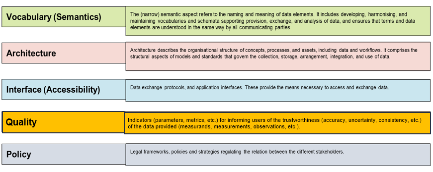
The factors together should cover all aspects that play a role in enabling interoperability of geospatial data and information. Design criteria for the factors should be cohesion, independence, and modularity.
Cohesion (internally) is accomplished by grouping them according to specific knowledge and competences required to tackle the respective issues. This ‘separation of concerns’ known from system engineering should ensure that the individual aspects are addressed in the most adequate way by experts of the respective fields without having to deal with the complexity of the entire system all the time.
Independence means that specific (fundamental) aspects (e.g. data formats) should be proprietary to one factor. In this way parallel or duplicate solution development can be avoided.
Modularity must ensure that all factors together build a functional ensemble in which it is clear which covers what and how they all work together.
The interoperability factors assemble certain, hopefully related, competencies that should be dwelled on whenever interoperability is desired or required in a project or process. Most CEOS activities are targeted at enhancing interoperability, they all should scrutinise their work with respect to the framework factors.
Contact Us
Please feel free to contact the Data Interoperability and Use Interest Group point of contact, Nitant Dube (ISRO) with any comments or questions about the group and its activities.