The second RO Demo activation, initiated on March 5th in response to Hurricanes Eta-Iota impacting Honduras, Guatemala, Nicaragua, and El Salvador, prompted extensive damage and loss assessments. The activation entailed four main activities: maintaining Copernicus EMS Grading maps for Honduras, Guatemala, and Nicaragua to aid in the recovery phase, conducting sectoral impact analyses focusing on agriculture in Honduras and Guatemala, and infrastructure in Honduras’ Sula Valley, developing a framework and decision tree for post-disaster EO usage in Central America, and enhancing the capacity for EO data interpretation and integration at regional entities like CEPREDENAC, in collaboration with CEOS WGCapD.
Copernicus EMS Rapid Mapping was activated to support information in the Sula Valley and the El Cajon Reservoir, Honduras, on November 11 and December 3, respectively.
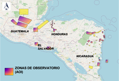
Map showing the AOIs affected. In total, 1,200 km² in Honduras, 1,900 km² in El Salvador, 7,500 km² in Nicaragua and 20,000 km² Guatemala.
The outcome of the Eta-Iota activation highlighted the capability to deliver complex products, notably demonstrated by the use of interferometric SAR for millimetre-level subsidence analysis, contributing to an enhanced understanding of long-term recovery efforts.
Lessons drawn from this experience underscore the efficacy of a user-driven approach in tailoring Earth observation-based solutions to meet specific needs. Deformation maps generated through SAR interferometry proved particularly effective, sparking considerable interest among end-users for future utilization in risk reduction strategies. Access to the technical expertise of international specialists emerged as a crucial factor in swiftly producing high-quality products during emergency activations.
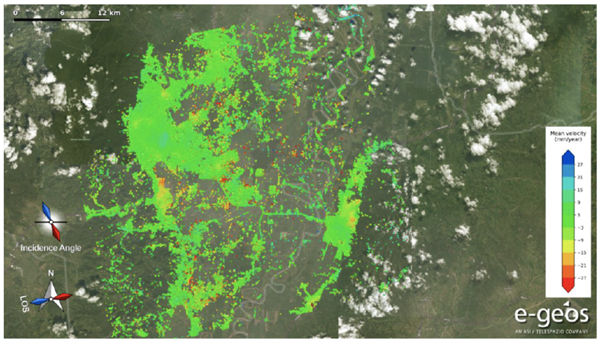
COSMO-SkyMed-based multi-temporal DInSAR deformation maps in Honduras, for ETA-IOTA activation. Red points represent targets subject to major deformations and hence needing major attention for risk analyses and monitoring purposes. Produced by e-geos.
However, certain limitations and challenges persist, necessitating a proactive approach to address them and pave the way forward. Disparities in capacity for data interpretation could impede the widespread exploitation, replication, and integration of these solutions into decision-making processes. Ensuring timely dissemination of information to decision-makers remains paramount. Furthermore, substantial investment in building technical capacity through training initiatives is imperative to empower stakeholders to effectively leverage Earth observation data for informed decision-making and disaster response strategies. The role of RO Liaison Officer was played by CEPREDENAC.
Other RO products for the hurricanes Eta and Iota can be found below.
For Honduras here.
For Guatemala here.
For Nicaragua here.