Overview
Landslides occur around the world, on every continent, and play an important role in the evolution of landscapes. They also represent a serious hazard in many areas of the world. Despite their importance, it has been estimated that past landslide and landslide potential maps cover less than 1% of the slopes in the landmasses. Systematic information on the type, abundance, and distribution of existing landslides is lacking. Even in countries where landslide information is abundant (e.g. Italy), the vast majority of landslides caused by meteorological (intense or prolonged rainfall, rapid snowmelt) or geophysical (earthquake) triggers go undetected. This paucity of knowledge has consequences on the design of effective remedial and mitigation measures. Systematic use of Earth observation (EO) data and technologies can contribute effectively to detect, map, and monitor landslides, and landslide prone hillsides, in different physiographic and climatic regions.
Landslide Pilot
The CEOS Landslide Pilot aims to demonstrate the effective exploitation of satellite EO across the full cycle of landslide disaster risk management, including preparedness, response, and recovery at global, regional, and local scales, with a distinct multi-hazard focus on cascading impacts and risks.
The Landslide Pilot is focusing efforts on three objectives ( 2016-2019):
- Establish effective practices for merging different Earth Observation data (e.g. optical and radar) to better monitor and map landslide activity over time and space.
- Demonstrate how landslide products, models, and services can support disaster risk management for multi-hazard and cascading landslide events.
- Engage and partner with data brokers and end users to understand requirements and user expectations and get feedback through the activities described in objectives 1-2.
The Landslide Pilot was endorsed in April 2016 and work started in fall 2016. The pilot is focused on two main regions, with several secondary, experimental regions. The main regions are Nepal and the Pacific Northwest United States, including Washington and Oregon. Plans for the experimental regions are still in development, but include: Southeast Alaska, China, the Caribbean (Haiti and Lesser Antilles), Peru, and Indonesia.
Detailed results
China Pilot PDF | China Pilot DOC
News/Events:
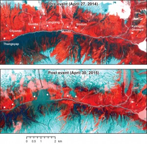
Landsat 8 Reveals Extent of Quake Disaster in Nepal’s Langtang Valley
The magnitude 7.8 Gorkha earthquake that struck Nepal on April 25, 2015, caused extensive damage in Kathmandu Valley and severely affected Nepal’s rural areas. Space agencies around the world provided extensive resources in a huge international effort.
Landslide Pilot Co-Leads:
Dr. Dalia Kirschbaum, NASA
Dr. Jonathan Godt, U.S. Geological Survey
Dr. Jean-Philippe Malet, Université de Strasbourg
Dr. Sigrid Roessner, GFZ German Research Centre for Geosciences
