Recovery Observatory
 Joint with WGDisasters.
Purpose: Space agencies already organize the emergency response after disasters (International Charter) but have little or no coordination for the post-crisis part of the disaster management cycle. The Recovery Observatory aims at demonstrating the value of using satellite Earth Observations to support Recovery from a major disaster:
- Assessment of damages on built and natural areas (detailed from response work)
- Change monitoring
- Reconstruction planning
- Reconstruction monitoring
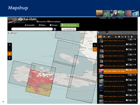
Background: The Recovery Observatory is a CEOS initiative, led by Working Group Disasters, in order to handle this post-crisis phase. This initiative is based on Lessons Learned by CNES from Kal-Haiti project (precursor of a Recovery Observatory) after 2010’s earthquake in Haiti.
WGISS has supported the Recovery Observatory with a number of services:
The services provided by the Recovery Observatory are the following:
- A collaborative Web-based workspace, including
- A public Web portal
- User groups and communities collaborative tools (comments, posts, follow…)
- User upload of reports, publications, added-value products, in Situ data …
- A map display of full resolution geo-referenced images :
- optical imagery (all types)
- radar imagery (X, C, L-bands)
- airborne data
- License management
- And products search capability with
- multi-criteria search (including geographic and temporal)
- map-based search
More information on the Recovery Observatory can be found here.
GA.4.Disasters
The Global Earth Observation System of Systems (GEOSS) Architecture for the use of Satellites for Disasters & Risk Assessment (GA.4.Disasters)
Joint with WGDisasters.
Purpose: The CEOS Working Group on Information Systems & Services (WGISS) project on the GA.4.Disasters is complete. Please read the final report: The GEOSS Architecture for the Use of Remote Sensing Products in Disaster Management and Risk Assessment, published in December 2013.
Background: The purpose of the GA.4.Disasters project was to address the use of satellites, sensors, models, and associated data products to support disaster response and risk assessment. The purpose of this GEOSS architecture was to provide an enterprise perspective for managing distributed systems and web services for disaster management. The intent was also to provide a common vocabulary to describe the GEOSS building blocks and how they are composed. WGISS evaluated existing and proposed disaster response and risk assessment processes as a point of departure in evolving the architecture descriptions. Key proof-of-concept prototypes were implemented to refine the architecture, to capture lessons learned, and to recommend standards for web service and system interfaces.
Water Portal
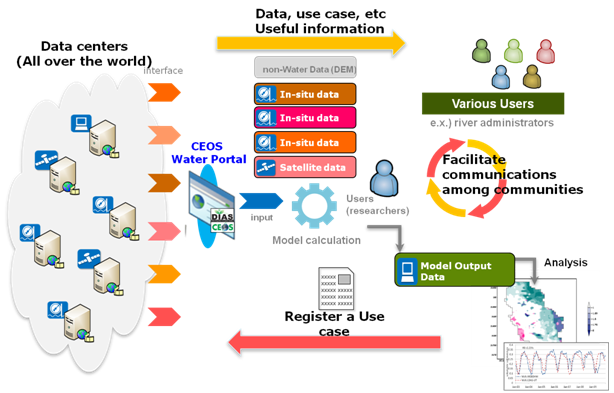
The CEOS Water Portal concept
Purpose: The goal of the CEOS Water Portal Project was to provide assistance to scientists and general users (or non-researchers) from the water domain in the development of data services associated with data integration and distribution.
Background: For several years in 2000s, WGISS Test Facility for CEOP (WTF-CEOP) project was tackled by the lead of JAXA to meet the demand of CEOP user community to develop the data integration services. With the fulfillment of the task, the project ended in 2009.
Partners: CEOS Water Portal Data Partners include the National Aeronautics & Space Administration (NASA) and the National Oceanic & Atmospheric Administration (NOAA).
More information can be found in the CEOS Water Portal Implementation Plan.