Group on Earth Observations – Data Access for Risk Management
Increased severity of weather events and rapid urbanization has led to growing economic and human losses from disasters; by 2050, the number of people exposed to storms and earthquakes in large cities could double and by 2100, damages from weather-related hazards may triple. Nine of the ten fastest growing urban mega-cities in the world are in Asia, and most of these are in vulnerable coastal areas.[1]
International organisations are taking action for risk prevention, mitigation, and preparedness through improved disaster risk reduction (DRR) policies and programmes. As part of this effort, space agencies working through the Committee on Earth Observation Satellites (CEOS) have implemented a series of actions in the framework of the Group on Earth Observations (GEO) –including the recently approved GEO-DARMA project– aimed at fostering the use of Earth observation (EO) data to support DRR, providing more accurate risk data for a better informed decision making. These initiatives seek to raise the awareness within disaster risk management (DRM) communities of the benefits of using satellite EO in all phases of DRM.
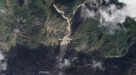
Figure 1: Landslide Zhouqu County of China’s Gansu Province in 2010, Credit: NASA
Progress in every aspect of Disaster Risk Reduction (DRR) requires strong international collaboration. Limited resources prevent any single group or organisation from address every aspect of DRR. Disasters are complex problems demanding a collective response. At the 3rd United Nations World Conference on Disaster Risk Reduction (WCDRR, Sendai, Japan, 14-18 March 2015), the global disaster community sought to address this coordination of effort through the adoption of the Sendai Framework for Disaster Risk Reduction 2015-2030. GEO-DARMA, an open initiative undertaken with partners from both satellite and non-satellite organisations, aims at supporting the practical implementation of some critical elements of the Framework.
Several studies and R&D activities demonstrate that Earth observations (EO) could play an increasingly important role in making societies more resilient to natural hazards and more adaptive to climate change, and could contribute significantly to DRR. Today, the huge volume of EO data, most of them free of charge, is largely unexploited except during the response phase, where EO is used operationally to support rapid mapping of damage and impact by organisations such as the International Charter Space and Major Disasters, the Copernicus Emergency Management Service and Sentinel-Asia. Large-scale use of EO data for other phases of DRM, particularly from satellites, is hindered by a lack of user awareness of possible applications, the challenges of collecting very large volumes of data that are sometimes commercial, and the complexity of both acquiring data from a wide range of providers and delivering ready-to-use risk information products to the end user. Ensuring high-quality risk-related information to support national and local decision makers requires the combined use of multiple sources and tools, including satellite, airborne and in-situ EO measurements; socio-economic data; computer models; and higher order information products derived from EO data. Synergistic use is possible only through international cooperation efforts. The GEO-DARMA initiative will bring together relevant stakeholders from governments, intergovernmental organizations, the UN system and civil society.
DARMA = Data Access for Risk Management.
The Japanese Daruma or Darma is a traditional handmade wishing doll, often referred to as a “goal doll”, that keeps people focused on achieving their goals.
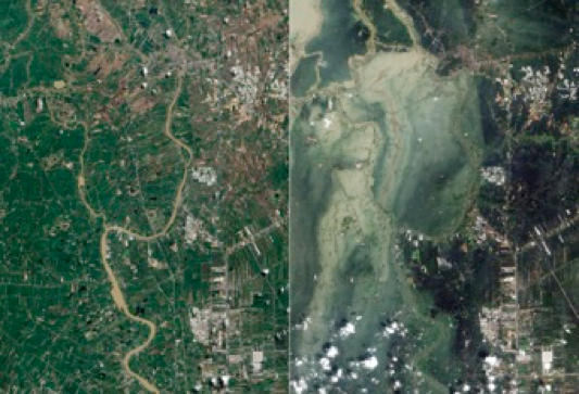
Figure 2: Flooding in Ayutthaya and Pathum Thani Provinces in October (right), compared to before the flooding in July (left), Credit: USGS NASA Earth Observatory
GEO-DARMA aims to support risk reduction activities through the implementation of end user priorities in line with the Sendai Framework on a trial basis in regions of the developing world. The main goal is to address critical issues related to Disaster Risk Reduction (DRR) affecting countries in three regions: South-East Asia, Latin America/Caribbean, and Africa. This would be done through a series of projects (initially demonstrators) that rely on the use of multiple sources of observation (space, in-situ, socio-economic, models outputs, etc.). Each project will involve data providers, data & information practitioners, regional institutions, governmental agencies, local decision makers, and scientists. Main outcomes (information products) from each project will be defined and generated with the objective of improving the quality and accuracy of information made available to national and local decision-makers in political and socio-economic sectors, to implement disaster risk reduction and resilience measures, during all disaster risk management phases, whenever those products and services require satellite EO combined with other sources of data (in-situ ground observations, socio-economic, model outputs). The ultimate goal is to establish an inclusive, comprehensive process to address local DRR requirements by using EO technologies efficiently. Long-term outcomes of GEO-DARMA are to foster the use of EO data and EO-based risk information by end users and to increase awareness within donor agencies of the promise of EO solutions. EO-related capacity building is a key challenge in many developing countries. GEO-DARMA includes a capacity building component both at the outset, from the project initiators towards early pilot countries, and throughout the project, as knowledge gained in the early phases is transferred between pilot countries and the GEO-DARMA effort is extended from early adopters to other countries in region.
The Partners sought for GEO-DARMA include:
- Representatives from national end user communities, national institutions and agencies;
- International and regional stakeholders knowledgeable about regional issues related to disaster risk management, such as relevant UN agencies, GFDRR[2], regional and international development banks;
- EO and non-EO data providers (e.g. satellite data providers such as CEOS[3] Agencies (including space agencies) and commercial satellite operators when possible);
- Providers of risk and other relevant information derived from EO data (e.g. practitioners such as value added information providers), including the commercial sector, scientists, and researchers.
Three phases are foreseen:
| PHASE | DURATION | |
| 1 | Concept phase | The Concept Phase began in December 2016 and is expected to continue to mid-2017. A Concept Phase workshop is planned in conjunction with the Global Platform meeting in Cancun May 22-26, 2017. |
| 2 | Prototyping phase | Beginning mid-2017, the prototyping phase aims to set up demonstrators in representative areas to demonstrate the added value of satellite data for multi-hazard DRR in an international context. Prototyping might start at different times depending on the specific projects. It is not envisaged to continue the prototyping activities including early operations beyond a period of 4 years, at which point a go/no-go decision is made to determine sustainability and implementation of steady-state operations. |
| 3 | Operational phase | On a case-by-case basis, individual projects will move from prototyping to operations after a clear path forward has been established, demonstrating sustainability, added-value or stakeholder benefit, and vision for on-going operations outside the scope of the demonstrator. |
The GEO-DARMA project is managed by a Technical Committee, consisting of representatives from volunteer partner organizations, and receives advice and guidance from a high-level Steering Committee.
For more information about GEO-DARMA or to express your interest in contributing, please contact Ivan Petiteville.
[1] Demographia World Urban Areas (2013): http://demographia.com/db-worldua.pdf
[2] Global Facility for Disaster Reduction and Recovery (GFDRR)
[3] Committee on Earth Observation Satellites – www.ceos.org