The Committee on Earth Observation Satellites (CEOS) has formed a coastally focused team (COAST) to advance free, open source data which better inform society of coastal issues. CEOS COAST incorporates various Earth Observation data products on coastal hazards, including: bathymetry, coastline mapping, flooding and inundation, habitat suitability and sediment transport. Access to these products and other curated datasets and information is available through an Application Knowledge Hub (AKH) that debuted in early 2023 (Dash 2022). COAST has selected 5 geographic pilot regions around the world to demonstrate these products, where potential societal impact is high: Bay of Bengal, Chesapeake Bay, Rio de La Plata Estuary, western coast of Africa, and Pacific and Caribbean Small Island Nations, CEOS COAST is engaging identified stakeholders in the co-design and testing of these products to provide information they need in the ways they want it delivered, and with a lowered barrier to data access.
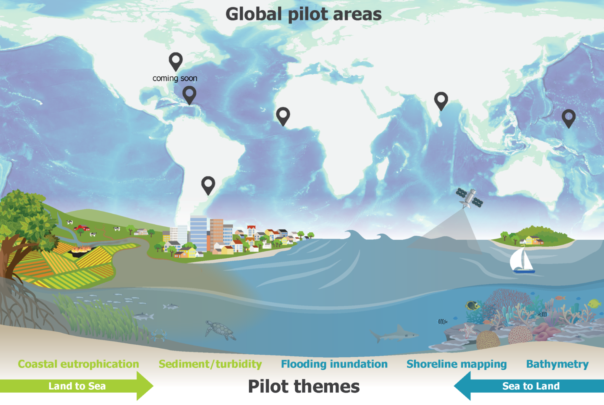
CEOS COAST is an endorsed UN Ocean Decade Contribution currently co-lead by National Oceanic and Atmospheric Administration (NOAA) and Indian Space Research Organisation (ISRO), with product leadership provided by European Space Agency (ESA), Geoscience Australia (GA), National Aeronautics and Space Administration (NASA), and GEO BluePlanet Initiative. Below we summarize some COAST products co-designed with users.
Coastline Mapping: African coastlines are under increasing pressure from erosion and coastal change, with a large proportion of the population in the region highly dependent on this dynamic coastal and marine environment for their economic livelihood. The ability for West African countries to understand historic coastal change and impacts from erosion mitigation is crucial to more effective future coastal management. GA, as part of COAST, applied its Digital Earth Australia (DEA) Coastlines workflow (Bishop-Taylor et. al., 2021; Geoscience Australia website link, 2021) to the West African region, demonstrating the ability to produce historical annual coastlines positions over the last few decades. Working with in-country partners, this data has improved understanding of complex coastal processes at work in this region, and DEA will release it as a continent-wide African Coastlines service. Within Chesapeake Bay and using the methodology described above, COAST developed a shoreline mapping product for the period 1984-2021, based on historical imagery collected by high-resolution satellites (Landsat-5/7/8 and Sentinel-2A/B). COAST’s satellite-derived shorelines demonstrate reasonable agreement with field assessments (1937-2009).
Flooding: Testing of flood algorithms for satellite-derived data products from low-Earth orbit (LEO) and geostationary (GEO) platforms continues. Final products include: Blended Multiplatform Flood Detection and Coastal Inundation, covering extent, depth, and condition. Two new algorithms for NOAA’s Visible Infrared Imaging Radiometer Suite (VIIRS) and GEO Advanced Baseline Imager (ABI) show excellent potential and team members are working to enable public access to these products through the COAST AKH in 2023 (Li, et al, 2018). The application of all weather synthetic aperture radar (SAR) for street level flood mapping is also being evaluated (Qing et al., 2021). The use of multi-sensor at higher resolutions ensures that daily local flooding monitoring can be applied near real time flood support and improved climatological assessments.
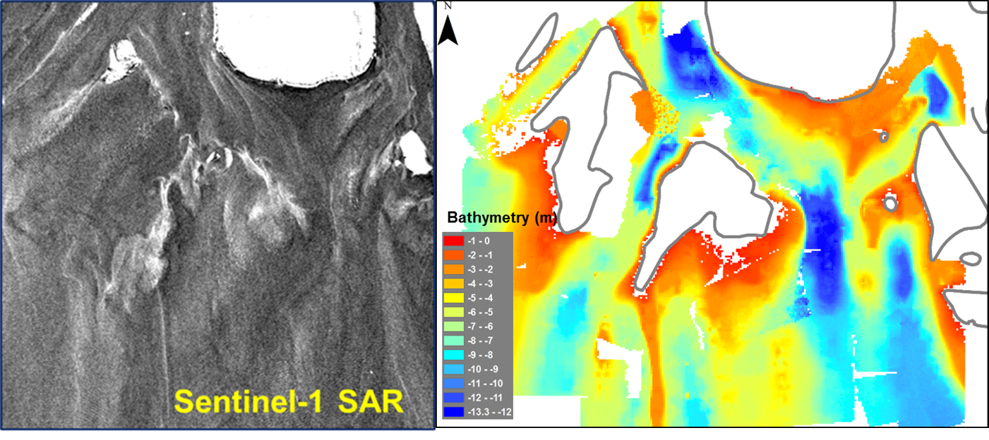
Sentinel-1 SAR imagery (left) and the estimated bathymetry of a river delta (right).
Bay of Bengal Bathymetry: Bay of Bengal, in the Northern Indian Ocean, is frequently affected by tropical cyclones, yet hosts diverse coastal wetlands substantially impacted by humans. Major perineal rivers like Ganga-Brahmaputra, Irrawaddy, Mahanadi, Krishna-Godavari discharge into Bay of Bengal forming deltaic plains. These deltaic plains of Bay of Bengal form among the world’s largest mangrove ecosystems, like the Sundarbans. Tropical cyclones cause havoc by inundating coastal population centers and causing widespread ecosystem damage, especially along low-lying coastal deltas. To address this, the Space Applications Center in the Indian Space Research Organisation (SAC-ISRO) which co-chairs COAST, is estimating bathymetry via Sentinel -1 Synthetic Aperture Radar satellite images. Coastal bathymetry, especially in deltaic regions, varies with hydrodynamics and large-scale sediment inputs. Updated bathymetry estimates are essential to accurate cyclone storm surge inundation forecasts. Using a radar backscatter model (Rajput et. al., 2020), deltaic features are compared to existing bathymetry charts to highlight changes (see image below). A machine-learning based technique monitors the long-term shoreline changes for the Bay of Bengal’s ‘blue-flagged beaches” – a voluntary certification of meeting and maintaining stringent environmental, educational, safety, and accessibility criteria.
Habitat Suitability Index/Mapping Suite: COAST’s Habitat Suitability products aim to provide regional stakeholders, such as partners at the Virginia Institute of Marine Science (VIMS), with a robust look at satellite-derived water quality factors which influence Submerged Aquatic Vegetation (SAV) growth throughout the Chesapeake Bay pilot region. The product suite maps those areas of Chesapeake Bay most hospitable for seagrass and macroalgal growth and optimal for aquaculture, applying literature-defined thresholds for satellite-derived factors such as turbidity, chlorophyll-A, and temperature. Already available is a time series of Landsat-8 and Sentinel-2A/B high resolution imagery from 2015-2021, processed with a coastal atmospheric correction, to characterize changes in turbidity and chlorophyll-a content throughout the SAV growing season in the bay.
Coastal Eutrophication Indicators: COAST is working to develop products to support assessment of the marine pollution Sustainable Development Goal (SDG) target 14.1. The primary indicator used for measuring coastal eutrophication is direct measurements of nutrients and models, but many countries lack this type of data. GEO Blue Planet is working in collaboration with UN Environment (the custodian agency for target 14.1), to test satellite-derived sub-indicators for 14.1.1a. In this context, multiple chlorophyll-a observations and derived global products from ESA, NASA, and NOAA form an indicator (UNEP, 2021), which COAST will augment user access. Ongoing efforts by UNEP and GEO BluePlanet include regional testing of products developed for the Northwest Pacific region (Terauchi, 2018; Maure, 2021) and the European Seas (Brando, 2022). COAST will work with stakeholders to make similar, regionally-tuned products and indicators available.
Application Knowledge Hub: Users access COAST products and information through a free public Application Knowledge Hub (AKH). This online tool enables simultaneous display of COAST’s satellite-based products, available social data and indicators, and in situ measurements on base maps. Major coastal events with significant socio-economic, ecological and physical impacts (storms, harmful algal blooms, etc.) are featured in storyboards.

User’s view of the COAST Application Knowledge Hub.
 COAST future product development will include polar coastal areas, Blue Carbon information and expanding our portfolio. CEOS COAST expects co-design and training with stakeholders to continue throughout the UN Ocean Decade. We welcome new stakeholders, partners, and patrons. If you would like to get involved in CEOS COAST, please email our co-chairs Paul.DiGiacomo@noaa.gov (NOAA) or rashmi@sac.isro.gov.in (ISRO).
The contents of this article are solely the opinions of the authors and do not constitute a statement of policy, decision, or position on behalf of the NOAA or the US Government. This work was supported by the NOAA/NESDIS Ocean Remote Sensing (ORS) Program.
References:
Dash, Prasanjit. 2022. Monitoring coastal events and changes using satellite data and contextual information: towards a CEOS COAST application knowledge hub. GHRSST XXIII international science team meeting, 27 June-1 July 2022, online and in-person (Barcelona) https://zenodo.org/record/7119481#.Y3fR5XbMI2w
Bishop-Taylor, R., Nanson, R., Sagar, S., Lymburner, L., 2021. Mapping Australia’s dynamic coastline at mean sea level using three decades of Landsat imagery. Remote Sensing of Environment 267.
Geoscience Australia, 2021. Digital Earth Australia Coastlines, Version 1.1.0.
Geoscience Australia website link 2021: https://cmi.ga.gov.au/data-products/dea/581/dea-coastlines
Sanmei Li, DonglianSun, Mitchell Goldberg, Bill Sjoberg, David Santek, Jay P. Hoffman, Mike DeWeese, Pedro Restrepo, Scott Lindsey, Eric Holloway. 2018. Automatic near real time flood detection using Suomi NPP/VIIRS data, Remote Sensing of Environment, 204.
Qing Yang, Xinyi Shen*, Emmanouil Anagnostou, Jack Eggleston, and Albert Kettner “A High- Resolution Flood Inundation Archive (2016–the Present) from Sentinel-1 SAR Imagery over CONUS”, Bulletin of the American Meteorological Society, DOI:10.1175/BAMS-D-19-0319.1.
Rajput, P, Ratheesh R, Francis S, Thomaskutty A.V, Agrawal R and Rajawat A.S. 2021. Investigating shallow water bottom feature using SAR data along Gulf of Khambhat, India, Remote Sensing Applications: Society and Environment, 23, 100592.
United Nations Environment Programme. 2021. Understanding the State of the Ocean: A Global Manual on Measuring SDG 14.1.1, SDG 14.2.1 and SDG 14.5.1. https://wedocs.unep.org/20.500.11822/35086.
Terauchi, G. et al. 2018. Assessment of eutrophication using remotely sensed chlorophyll-a in the Northwest Pacific region. In Remote Sensing of the Open and Coastal Ocean and Inland Waters (eds. Frouin, R. J. & Murakami, H.) 17 (SPIE). https://doi.org/10.1117/12.2324641.
Maúre, E.d.R., Terauchi, G., Ishizaka, J. et al. 2021. Globally consistent assessment of coastal eutrophication. Nat Commun 12, 6142 https://doi.org/10.1038/s41467-021-26391-9
Brando, V.E., S. Pardo, S. Sathyendranath, B. Howey, P. Land, T. Jackson, R. Santoleri, M. Sammartino, S. Colella, K. von Schuckmann, D. Ghafari, E. Smail, K. VanGraafeiland, S. Ramachandran, V. P. Lance, M. Wang. 2022. Potential eutrophication of European waters using satellite derived chlorophyll following the UN Sustainable Development Goal 14 framework. In: Copernicus Ocean State Report, Issue 6, Journal of Operational Oceanography, 15:sup1, s83-s91; DOI: 10.1080/1755876X.2022.2095169